Uluru
It crops out near the centre of Australia in the southern part of the Northern Territory, 335 km (208 mi) south-west of Alice Springs.
This word is a proper noun, with no further particular meaning in the Pitjantjatjara dialect, although it is used as a local family name by the senior traditional owners of Uluru.
The order of the dual names was officially reversed to "Uluru / Ayers Rock" on 6 November 2002 following a request from the Regional Tourism Association in Alice Springs.
Uluru and Kata Tjuta were first mapped by Europeans in 1872 during the expeditionary period, which was made possible by the construction of the Australian Overland Telegraph Line.
In the late 19th century, pastoralists attempted to establish themselves in areas adjoining the Southwestern/Petermann Reserve and interaction between Aṉangu and white people became more frequent and more violent.
[12] On 26 October 1985, the Australian government returned ownership of Uluru to the local Pitjantjatjara people, with a condition that the Aṉangu would lease it back to the National Parks and Wildlife agency for 99 years and that it would be jointly managed.
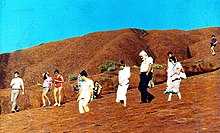
An agreement originally made between the community and Prime Minister Bob Hawke that the climb to the top by tourists would be stopped was later[when?]
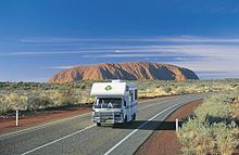
From Uluru it is 17 km (11 mi) by road to the tourist town of Yulara, population 3,000, which is situated just outside the national park.
[6] On 11 December 1983, the Prime Minister of Australia, Bob Hawke, promised to hand back the land title to the Aṉangu traditional custodians and caretakers and agreed to the community's 10-point plan which included forbidding the climbing of Uluru.
[13][21] A chain handhold, added to the rock in 1964 and extended in 1976, made the hour-long climb easier,[22] but it remained a steep, 800 m (0.5 mi) hike to the top, where it can be quite windy.
[23][24] It was recommended that individuals drink plenty of water while climbing, and that those who were unfit, or who suffered from vertigo or medical conditions restricting exercise, did not attempt it.
Under their joint Uluṟu-Kata Tjuṯa National Park Management Plan 2010–20, issued by the Director of National Parks under the Environment Protection and Biodiversity Conservation Act 1999, clause 6.3.3 provides that the Director and the Uluṟu-Kata Tjuṯa Board of Management should work to close the climb upon meeting any of three conditions: there were "adequate new visitor experiences", less than 20 per cent of visitors made the climb, or the "critical factors" in decisions to visit were "cultural and natural experiences".
[29] Several controversial incidents on top of Uluru in 2010, including a striptease, golfing and nudity, led to renewed calls for banning the climb.
[37] In September 2020, Parks Australia alerted Google Australia to the user-generated images from the Uluru summit that have been posted on the Google Maps platform and requested that the content be removed in accordance with the wishes of Aṉangu, Uluru's traditional owners, and the national park's Film and Photography Guidelines.
[46][47][48] An inselberg is a prominent isolated residual knob or hill that rises abruptly from and is surrounded by extensive and relatively flat erosion lowlands in a hot, dry region.
[50] Uluru's homogeneity and lack of jointing and parting at bedding surfaces inhibits the development of scree slopes and soil.
[50] For the purpose of mapping and describing the geological history of the area, geologists refer to the rock strata making up Uluru as the Mutitjulu Arkose, and it is one of many sedimentary formations filling the Amadeus Basin.
This lack of sorting and grain rounding is typical of arkosic sandstones and is indicative of relatively rapid erosion from the granites of the growing mountains to the south.
The layers of sand were nearly horizontal when deposited, but were tilted to their near vertical position during a later episode of mountain building, possibly the Alice Springs Orogeny of Palaeozoic age (400–300 Ma).
The second tells of two tribes of ancestral spirits who were invited to a feast, but were distracted by the beautiful Sleepy Lizard Women and did not show up.
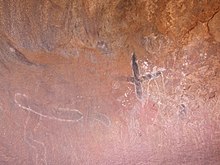
[53] The Commonwealth Department of Environment's webpage advises:[52] Many other Tjukurpa such as Kalaya (emu), Liru (poisonous snake), Lungkata (blue-tongue lizard), Luunpa (kingfisher) and Tjintir-tjintirpa (willie wagtail) travel through Uluṟu-Kata Tjuṯa National Park.
The men decorated and raised the ceremonial pole (Ngaltawata) and began inma, while the women gathered and prepared bush food, storing seed cakes (nyuma) in their caves.
The Wintalka men went back and told their people, who got angry and created an evil spirit, in the form of an enormous devil-dog called Kurpany, in order to wreck the Mala inma.
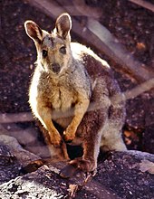
Moves are supported for the reintroduction of locally extinct animals such as malleefowl, common brushtail possum, rufous hare-wallaby or mala, bilby, burrowing bettong and the black-flanked rock-wallaby.
[10][57][58] The mulgara is mostly restricted to the transitional sand plain area, a narrow band of country that stretches from the vicinity of Uluru to the northern boundary of the park and into Ayers Rock Resort.
The bat population of the park comprises at least seven species that depend on day roosting sites within caves and crevices of Uluru and Kata Tjuta.
Hunting is largely confined to the red kangaroo, bush turkey, emu and lizards such as the sand goanna and perentie.
Of the 27 mammal species found in the park, six are introduced: the house mouse, camel, fox, cat, dog and rabbit.
These species are distributed throughout the park, but their densities are greatest near the rich water run-off areas of Uluru and Kata Tjuta.
Flora in Uluṟu-Kata Tjuṯa National Park can be broken into these categories: Trees such as the mulga and centralian bloodwood are used to make tools such as spearheads, boomerangs and bowls.