United States National Radio Quiet Zone
It includes all land with latitudes between 37° 30′ 0.4″ N and 39° 15′ 0.4″ N, and longitudes between 78° 29′ 59.0″ W and 80° 29′ 59.2″ W.[1] Most broadcast transmitters in the central area of the Quiet Zone are required to operate at reduced power and use directional antennas.
However, owners of high-power transmitters, including television stations in the Harrisonburg–Staunton and Charlottesville markets, must coordinate their operations with the Green Bank Observatory.
The most severe restrictions to the general public are imposed within a 20-mile (32 km) radius of the Green Bank Observatory.
It does not have enforcement power[6] (although the FCC can impose a fine of $50 on violators[7]) but will work with residents to find solutions.
[11][12] The National Radio Quiet Zone Administrator at the Green Bank Observatory manages the enforcement policies.
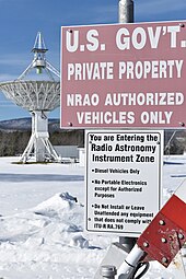
All unintentional radiators must be operated within the ITU-R RA.769 recommendations on protection criteria used for radio astronomical measurements.
The Federal Communications Commission (FCC) created the Quiet Zone in 1958 to protect the radio telescopes at Green Bank and Sugar Grove from harmful interference.
The Quiet Zone also protects the antennas and receivers of the U.S. Navy's Information Operations Command (NIOC) at Sugar Grove.