Upper Montclair, New Jersey
[11] The area is served as United States Postal Service ZIP Code 07043.
The area now known as Upper Montclair was first developed in the early 18th century as a rural community known as Speertown, named for John Speer, an early Dutch settler.
[14] The 2010 United States census counted 11,565 people, 4,178 households, and 3,146 families in the CDP.
Of all households, 20.3% were made up of individuals and 8.3% had someone living alone who was 65 years of age or older.
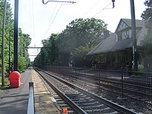
Upper Montclair is well connected to the rest of New Jersey and New York City on account of its transportation infrastructure.
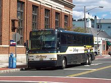
Public transportation options in Upper Montclair are buses and trains, both provided by New Jersey Transit, although commuter bus service to Manhattan was also provided until April 2023 by DeCamp Bus Lines.
New Jersey Transit's Montclair-Boonton Line runs through the neighborhood of Upper Montclair.
The area is also on NJ Transit's bus route 28, which goes from Montclair State University or Willowbrook Mall along Valley Road through Montclair, Glen Ridge and Bloomfield, to Downtown Newark.
Unlike many of Montclair's other commercial zones, it has outlets of several major chain stores.
People who were born in, residents of, or otherwise closely associated with Upper Montclair include: