Upper mantle
Crust and mantle are distinguished by composition, while the lithosphere and asthenosphere are defined by a change in mechanical properties.
[2] Earthquakes at shallow depths result from strike-slip faulting; however, below about 50 km (31 mi), the hot, high-pressure conditions inhibit further seismicity.
This can be seen using body waves from earthquakes, which are converted, reflected, or refracted at the boundary, and predicted from mineral physics, as the phase changes are temperature and density-dependent and hence depth-dependent.
[6] It is seen as single and double reflections in receiver functions for P to S conversions over a broad range of depths (640–720 km, or 397–447 mi).
[12][16] Estimates for the viscosity of the upper mantle range between 1019 and 1024 Pa·s, depending on depth,[17] temperature, composition, state of stress, and numerous other factors.
However, when large forces are applied to the uppermost mantle, it can become weaker, and this effect is thought to be important in allowing the formation of tectonic plate boundaries.
Observations of rocks exposed on the surface and other evidence reveal that the upper mantle is mafic minerals olivine and pyroxene, and it has a density of about 3.33 g/cm3 (0.120 lb/cu in)[1] Upper mantle material that has come up onto the surface comprises about 55% olivine and 35% pyroxene, and 5 to 10% of calcium oxide and aluminum oxide.
[1] The upper mantle is dominantly peridotite, composed primarily of variable proportions of the minerals olivine, clinopyroxene, orthopyroxene, and an aluminous phase.
Experiments on olivines and pyroxenes show that these minerals change the structure as pressure increases at greater depth, which explains why the density curves are not perfectly smooth.
At the base of the transition zone, ringwoodite decomposes into bridgmanite (formerly called magnesium silicate perovskite), and ferropericlase.
On 5 March 2007, a team of scientists on board the RRS James Cook embarked on a voyage to an area of the Atlantic seafloor where the mantle lies exposed without any crust covering, midway between the Cape Verde Islands and the Caribbean Sea.
The exposed site lies approximately 3 kilometres (1.9 mi) beneath the ocean surface and covers thousands of square kilometers.
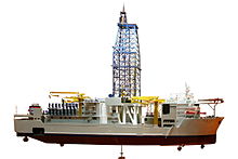
This record has since been surpassed by the ill-fated Deepwater Horizon mobile offshore drilling unit, operating on the Tiber prospect in the Mississippi Canyon Field, United States Gulf of Mexico, when it achieved a world record for total length for a vertical drilling string of 10,062 m (33,011 ft).
[24] The previous record was held by the U.S. vessel Glomar Challenger, which in 1978 drilled to 7,049.5 meters (23,130 feet) below sea level in the Mariana Trench.
A novel method of exploring the uppermost few hundred kilometers of the Earth was proposed in 2005, consisting of a small, dense, heat-generating probe that melts its way down through the crust and mantle while its position and progress are tracked by acoustic signals generated in the rocks.
[26] The probe consists of an outer sphere of tungsten about 1 metre (3 ft 3 in) in diameter with a cobalt-60 interior acting as a radioactive heat source.
In 2009, a supercomputer application provided new insight into the distribution of mineral deposits, especially isotopes of iron, from when the mantle developed 4.5 billion years ago.
[28] In 2023 JOIDES Resolution recovered cores of what appeared to be rock from the upper mantle after drilling only a few hundred meters into the Atlantis Massif.