Uruma
As such the city is considered the home of the starting point of the restoration of civil life in Okinawa immediately after the end of World War II.
A folk etymology, which was adopted by the city itself,[12] segments uruma into uru (fine sand or coral in Okinawan) and *ma (island?).
However, the association with Ulleung Island was soon forgotten because the reference to Silla was dropped when his poem was recorded in the Senzai Wakashū (1188).
The magiri were abolished in 1907 under Imperial Edict 46, and the central government extended the establishment of cities, towns, and village organization to Okinawa Prefecture.
[14][15] In the pre-war period Uruma had the most productive sugarcane industry in Okinawa Prefecture due to sources of irrigation and fertile soil.
The areas of present-day Uruma were affected in World War II during the initial part of the Battle of Okinawa.
A smaller invasion force captured Tsuken Island on the same day, and encountered stiff resistance from the Japanese military.
In 1946 the Advisory Council was moved to the village of Sashiki, now a district of Nanjō, refugees began a large-scale movement to return to their homes, and the population of Ishikawa decreased rapidly.
The camp was built and operated by the U.S. occupation forces, and is considered the starting point of the reconstruction and recovery of Okinawa after the war.
The F-100 crash contributed to ill will among the Okinawan population towards the U.S. occupation authorities, and strengthened calls for the island to be returned to the control of the Japanese government.
The area of Uruma on the Okinawan mainland is bordered by Kin Bay to the east, and has a long coastline with significant industrial development.
Runners cross from Yonashiro over the Mid-Sea Road, which is partially closed to traffic during the race, to Henza Island.
Amamikyu and Shinerikyu are worshipped at their tombs, and the noro priestess of Higa conducts prayers at the beginning of the year at the sites.
[26] Nearby are other holy sites related to Shinerikyu, Maitreya, and Nirai Kanai (most notably the Miruku Gate and Mount Yugafu).
There are a significant number of noro priestesses and yuta mediums on Hamahiga Island, the latter being typically female, but sometimes male.
[43] Bechtel Elementary School, located on Camp McTureous, is administered by Department of Defense Education Activity for English-speaking United States military dependents.
The Port of Kinwan (19,400 hectares (48,000 acres)) encompasses the coastal areas of Naha, Uruma, and other municipalities on Okinawa island.
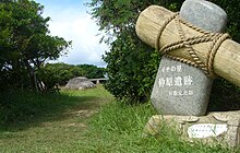
The site sits on a large limestone fault slope, and dates from the late Jōmon period, ca.
The Iha Shell Mound is approximately 60 centimetres (24 in) thick and covers an area of 150 square metres (1,600 sq ft).
The site includes remains of fish and animal bones, earthen and stoneware, and goods made out of horn.
Agena Castle sits at an altitude of 49 metres (161 ft), and is naturally protected by the Tengan River to the north.
The castle remains now hold numerous utaki sites of worship of the Ryukyuan religion, and are scattered with fragments of Chinese ceramics from the 14th to the 15th century.
It sits 98 meters (322 ft) above sea level on the small Katsuren Peninsula, and is flanked by the Pacific Ocean on two sides.
[59] United States military bases in Uruma cover 6.632 square kilometres (2.561 sq mi), or 12.97% of the total area of the city.
Camp Courtney is a United States Marine Base located in the north of Uruma on Kin Bay.
The camp was established in 1956 and occupies 1.348 square kilometres (0.520 sq mi) in the Konbu, Tengan, and Uken districts of Uruma.
[61][62] Camp McTureous is a United States Marine Base located in the west side of the Agena district of Uruma.
[63] White Beach Naval Facility, formally referred to as the Port Operations Naval Facility White Beach, is a United States Navy base located southern tip of the Katsuren Peninsula at the Northeast of Nakagusuku Bay, also known as Buckner Bay.
[69] The Japan Maritime Self-Defense Force Okinawa Naval Base is located directly adjacent to White Beach.
Logbooks of the privately owned merchant marine ship SS Schuyler Otis Bland show that chemicals agents were delivered to White Beach under armed guard on April 25, 1962, then transported to other areas of the island.