Velbert
Velbert is located on the hills of 'Niederberg' (meaning Lower Mountain), part of the Berg region, approx.
20 kilometres north-east of the capital of North Rhine Westphalia, Düsseldorf, and 12 kilometers north-west of Wuppertal on the south side of the Ruhr river.
The highest point in Velbert itself is 263 metres above sea level, at the corner of Friedrichstraße and Langenberger Straße.
There are also numerous suburbs, including Tönisheide, Losenburg, Nordpark, Langenhorst, Birth, Röttgen and Hefel.
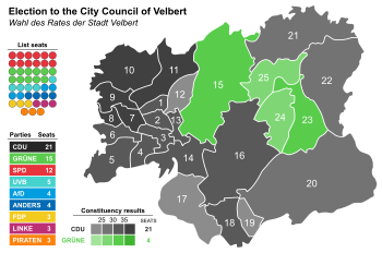
The most recent city council election was held on 13 September 2020, and the results were as follows: The first coat of arms was created in 1882 and abolished in local government reform of 1975.
It showed the lion of the Counts, later Dukes, of Berg (originally the symbol of Limburg) and keys referring to locksmithing, a traditional industry in Velbert.
Velbert also used to have a tram service, and was the meeting point of tramlines from Heidhausen, Neviges, Wülfrath and Hösel with Heiligenhaus.