Verkhoyansk Range
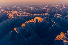
The Verkhoyansk Range (Russian: Верхоянский хребет, Verhojanskiy Hrebet; Yakut: Үөһээ Дьааҥы сис хайата, romanized: Üöhê Câñı sis xayata) is a mountain range in the Sakha Republic, Russia near the settlement of Verkhoyansk, well-known for its frigid climate.
across Yakutia, east of the Central Yakutian Lowland, and west of the Chersky Range, reaching the Lena Plateau to the south and the Yudoma-Maya Highlands to the southeast.
The two ranges were surveyed in 1934 by geologist Yuri Bilibin (1901–1952) together with mining engineer Evgeny Bobin (1897–1941) in the course of an expedition sent by the government of the Soviet Union.
Many right tributaries of the Lena flow westwards, having their sources in the range, including the Kyundyudey, Undyulyung, Begidyan, Sobolokh-Mayan, Menkere, Dzhardzhan, Uel-Siktyakh, Kuranakh-Siktyakh, Byosyuke, Tikyan, Dyanyshka, Lyapiske, Belyanka, Munni, Kele, Tukulan, Tumara, Nuora, and Baray, among others.
[3] The world's lowest temperatures for inhabited places have been recorded in this region, and there is quite deep snow cover for most of the year.