Appian Way
The Appian Way (Latin and Italian: Via Appia) is one of the earliest and strategically most important Roman roads of the ancient republic.
[1] Its importance is indicated by its common name, recorded by Statius,[2][3] of Appia longarum... regina viarum ("the Appian Way, the queen of the long roads").
[6] The Appian Way was a Roman road which the republic used as a main route for military supplies for its conquest of southern Italy in 312 BC and for improvements in communication.
[7][8] The Appian Way was the first long road built specifically to transport troops outside the smaller region of greater Rome (this was essential to the Romans).
The Samnites, now a major power after defeating the Greeks of Tarentum, occupied Neapolis to try to ensure its loyalty.
A man of discernment and perception, in the years of success he was said to have lost his outer vision[clarification needed] and thus acquired the name caecus, "blind".
Without waiting to be told what to do by the Senate, Appius Claudius began bold public works to address the supply problem.
By far the best known project was the road, which ran across the Pontine Marshes to the coast northwest of Naples, where it turned north to Capua.
On it, any number of fresh troops could be sped to the theatre of operations, and supplies could be moved en masse to Roman bases without hindrance by either enemy or terrain.
It is no surprise that, after his term as censor, Appius Claudius became consul twice, subsequently held other offices, and was a respected consultant to the state even during his later years.
The road was the main factor that allowed them to concentrate their forces with sufficient rapidity and to keep them adequately supplied, whereafter they became a formidable opponent.
Gravel was laid upon this, which was finally topped with tight fitting, interlocking stones to provide a flat surface.
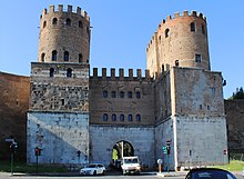
The road began in the Forum Romanum, passed through the Servian Wall at the porta Capena, went through a cutting in the clivus Martis, and left the city.
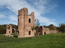
The Roman section still exists and is lined with monuments of all periods, although the cement has eroded out of the joints, leaving a very rough surface.
A stone causeway of about 31 kilometers (19 mi) led across stagnant and foul-smelling pools blocked from the sea by sand dunes.
It must have been during this time that they extended the Via Appia 35 miles beyond Capua past the Caudine Forks to a place the Samnites called Maloenton, "passage of the flocks".
The dates are somewhat uncertain and there is considerable variation in the sources, but during the Third Samnite War the Romans seem to have extended the road to Venusia, where they placed a colony of 20,000 men.
Roman expansion alarmed Tarentum, the leading city of the Greek presence (Magna Graecia) in southern Italy.
In 280 BC the Romans suffered a defeat at the hands of Pyrrhus at the Battle of Heraclea on the coast west of Tarentum.
Wintering in Campania, he withdrew to Apulia in 279 BC, where, pursued by the Romans, he won a second costly victory at the Battle of Asculum.
Supplied by that same road, the Romans successfully defended the region against Pyrrhus, crushing his army in a two-day fight at the Battle of Beneventum in 275 BC.
[14][15] In the first half of the 20th century, the professor of ancient Roman topography Giuseppe Lugli managed to discover, with the then-innovative technique of photogrammetry, what probably was the route of the Appian Way from Gravina in Puglia (Silvium) up to Taranto.
A further piece of evidence for Lugli's proposed path is the presence of a number of archaeological remains in that region, among them the ancient settlement of Jesce.
However, the toponym Murgia Catena defined too large an area, not allowing a clear localization of the Appian Way station.
[21] In 1943, during World War II, the Allies fell into the same trap Pyrrhus had retreated to avoid, in the Pomptine fields, the successor to the Pontine Marshes.
The marsh remained, despite many efforts to drain it, until engineers working for Benito Mussolini finally succeeded (even so, the fields were infested with malarial mosquitos until the advent of DDT in the 1950s).
Hoping to break a stalemate at Monte Cassino, the Allies landed on the coast of Italy at the Anzio-Nettuno area – ancient Antium – which was midway between Ostia and Terracina.
[22][23] After the fall of the Western Roman Empire, the road fell out of use; Pope Pius VI ordered its restoration.
The first 5 kilometers (3 mi) are still heavily used by cars, buses and coaches but from then on traffic is very light and the ruins can be explored on foot in relative safety.
The construction of Rome's ring road, the Grande Raccordo Anulare or GRA, in 1951 caused the Appian Way to be cut in two.