Vice-county
The vice-counties remain unchanged by subsequent local government reorganisations, allowing historical and modern data to be more accurately compared.
[4] In 2002, to mark the 150th anniversary of the introduction of the Watsonian vice-county system, the NBN Trust commissioned the digitisation of the 112 vice-county boundaries for England, Scotland and Wales, based on 420 original one-inch to the mile maps annotated by Dandy in 1947, and held at the Natural History Museum, London.
[5][6] Up until that point, county recorders only had general access to a set of two fold-out vice-county maps covering the entirety of Great Britain, published in 1969.
[7] The vice-county system was first introduced by Hewett Cottrell Watson in the third volume of his Cybele Britannica published in 1852.
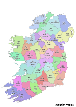
[2] In 1901, Robert Lloyd Praeger extended the system of vice-counties to Ireland and its off-shore islands, based on an earlier suggestion by C. C. Babington in 1859.
Praeger's fieldwork mostly predates and ignores the county boundary changes made in 1899 under the Local Government (Ireland) Act 1898.