Vinland
The etymology of the Old Norse root vin- is disputed; while it has usually been assumed to be "wine", some scholars give credence to the homophone vin, meaning "pasture" or "meadow".
"[11] This etymology is retained in the 13th-century Grœnlendinga saga, which provides a circumstantial account of the discovery of Vinland and its being named from the vínber, i.e. "wineberry", a term for grapes or currants (black or red), found there.
[14] This interpretation of Vinland as "pasture-land" rather than "wine-land" was accepted by Valter Jansson in his classic 1951 dissertation on the vin-names of Scandinavia, by way of which it entered popular knowledge in the later 20th century.
On page 24 of "The Frozen Echo[16]" 1996, she writes, "The notion that the first syllable was vin with a short vowel (meaning ”green meadow”) has been so thoroughly discarded that we are left with the incontrovertible, long-vowelled vín or “wine”
Sophus Bugge (1902) read part of the inscription as: ᚢᛁᚿ᛫(ᛚ)ᛆ(ᛐ)ᛁᚭ᛫ᛁᛌᛆ uin (l)a(t)ią isa Vínlandi á ísa "from Vinland over ice".
This is highly uncertain; the same sequence is read by Magnus Olsen (1951) as: ᚢᛁᚿ᛫ᚴᛆ(ᛚᛐ)ᚭ᛫ᛁᛌᛆ uin ka(lt)ą isa vindkalda á ísa "over the wind-cold ice".
The next winter, Gudrid married a visiting Icelander named Thorfinn Karlsefni, who agreed to undertake a major expedition to Vinland, taking livestock.
Returning to Greenland with samples of grapes/currants, wheat and timber, he rescued the survivors from a wrecked ship and gained a reputation for good luck; his religious mission was a swift success.
Spending the winter as a guest at a farm on Greenland with Gudrid, Thorstein died of disease, reviving just long enough to make a prophecy about her future as a far-traveling Christian.
The next winter, Gudrid married a visiting Icelander named Thorfinn Karlsefni, who, with his business partner Snorri Thorbrandsson, agreed to undertake a major expedition to the new land, taking livestock with them.
Also contributing ships for this expedition were another pair of visiting Icelanders, Bjarni Grimolfsson and Thorhall Gamlason, and Leif's brother and sister Thorvald and Freydis, with her husband Thorvard.
Thorfinn and Snorri, with Freydis (plus possibly Bjarni), sailed down the east coast with 40 men or more and established a settlement on the shore of a seaside lake, protected by barrier islands and connected to the open ocean by a river which was navigable by ships only at high tide.
The explorers subsequently abandoned the southern camp and sailed back to Straumsfjord, killing five natives they encountered on the way, lying asleep in hide sacks.
[24] In the early 14th Century, a geography encyclopedia called Geographica Universalis was compiled at Malmesbury Abbey in England, which was in turn used as a source for one of the most widely circulated medieval English educational works, Polychronicon by Ranulf Higden, a few years later.
Both these works, with Adam of Bremen as a possible source, were confused about the location of what they called Wintland—the Malmesbury monk had it on the ocean east of Norway, while Higden put it west of Denmark but failed to explain the distance.
Neither mentioned grapes, and the Malmesbury work specifically states that little grows there but grass and trees, which reflects the saga descriptions of the area round the main Norse expedition base.
According to a 1969 article by Douglas McManis in the Annals of the Association of American Geographers,[30] The study of the early Norse voyages to North America is a field of research characterized by controversy and conflicting, often irreconcilable, opinions and conclusions.
These circumstances result from the fact that details of the voyages exist only in two Icelandic sagas which contradict each other on basic issues and internally are vague and contain nonhistorical passages.
The Skálholt Map, drawn in 1570 or 1590 but surviving only through later copies, shows Promontorium Winlandiae ("promontory/cape/foreland of Vinland") as a narrow cape with its northern tip at the same latitude as southern Ireland.
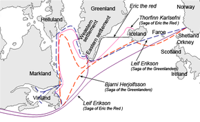
Although it is generally agreed, based on the saga descriptions, that Helluland includes Baffin Island, and Markland represents at least the southern part of the modern Labrador, there has been considerable controversy over the location of the actual Norse landings and settlement.
One of the few reasonably consistent pieces of information is that exploration voyages from the main base sailed down both the east and west coasts of the land; this was one of the factors which helped archaeologists locate the site at L'Anse aux Meadows, at the tip of Newfoundland's long northern peninsula.
[33] On the other hand, Sir Wilfred Grenfell, a medical missionary and scholar living in Newfoundland and Labrador in the early 20th century wrote of the issue of the location of Vinland that,[34] No reason has ever been shown why the Vikings would want to fare any farther than our beautifully wooded bays, with their endless berries, salmon, furs, and game, except that most people think of the east coast of Labrador as all barren, forbidding wastes, and forget that no part of it lies north of England and Scotland.Other clues appear to place the main settlement farther south, such as the mention of a winter with no snow and the reports in both sagas of grapes being found.
Carl Christian Rafn, in the first detailed study of the Norse exploration of the New World, "Antiquitates Americanae" (1837), interpreted these times as equivalent to 7:30 a.m. and 4:30 p.m., which would put the base a long way south of Newfoundland.
According to the 1880 Sephton translation of the saga, Rafn and other Danish scholars placed Kjalarnes at Cape Cod, Straumfjörð at Buzzards Bay, Massachusetts, and Straumsey at Martha's Vineyard.
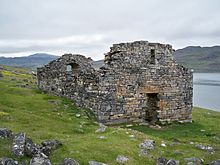
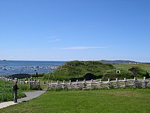
[37] In 1960, the remains of a small Norse encampment[7] were discovered by Helge and Anne Stine Ingstad at that exact spot, L'Anse aux Meadows in northern Newfoundland, and excavated during the 1960s and 1970s.
Many wooden objects were found at L'Anse aux Meadows, and radiocarbon dating confirms the site's occupation as being confined to a short period around 1000 CE.
Gustav Storm (1887) and Joseph Fischer (1902) both suggested Cape Breton; Samuel Eliot Morison (1971) the southern part of Newfoundland; Erik Wahlgren (1986) Miramichi Bay in New Brunswick; and Icelandic climate specialist Pall Bergthorsson (1997) proposed New York City.
[41] The insistence in all the main historical sources that grapes were found in Vinland suggests that the explorers ventured at least to the south side of the St. Lawrence River, as Jacques Cartier did 500 years later, finding both wild vines and nut trees.
As the Norse were searching for lumber, a material that was needed in Greenland, they found trees covered with Vitis riparia south of L'Anse aux Meadows and called them vinviðir.
Based on this textual interpretation Jakobsson considers that the Norse travels to Vinland failed to discover America as they did not bring about the paradigmatic shift in Christian geography of later voyages to the New World.