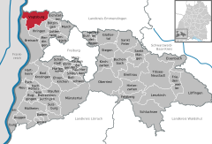
Vogtsburg
It has a population of about 5,700 and was created on January 1, 1975 through the unification of six former municipalities, initially under the name Oberrotweil,[3] and was renamed to Vogtsburg im Kaiserstuhl in April 1977.
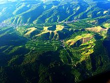
The horseshoe-shaped mountain range of the Kaiserstuhl opens to the west and forms the border of the area of Vogtsburg.
The relatively low height above sea level and the protected position between the Vosges Mountains and the Schwarzwald (the Black Forest) create a nearly Mediterranean microclimate.
The Kaiserstuhl consists of thick layers of loess (100 ft (30 m)), which, together with the special climate, is the main reason for the extraordinary fertility of this area.
The earliest archaeological finds in the village Oberbergen date to the times of the Linear Pottery culture during the Paleolithic era between 4000 and 2500 BC.
Archaeological finds in Bischoffingen give evidence of neolithic settlers of the Corded Ware culture.
The area of Oberbergen is considered to be the most important settlement in South Baden during the era of the Hallstatt culture.
Because of the horseshoe-shaped mountain range of the Kaiserstuhl, which opens only to the west, Vogtsburg was not easily accessible before the introduction of modern roads.
The results of the local elections from June 13 of 2004: The city economy is based primarily on the production of wine grapes.
In the villages of Achkarren, Oberrotweil, Schelingen and Altvogtsburg there are four churches designed by Friedrich Weinbrenner, a famous architect.
The reduced version built by the master builder Hans Voß has a choir and two adjoining rooms.
The church is now closed due to structural deterioration caused by water intrusion and vibration from traffic.