Volcanism of Iceland
Iceland experiences frequent volcanic activity, due to its location both on the Mid-Atlantic Ridge, a divergent tectonic plate boundary, and being over a hotspot.
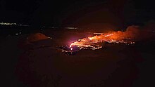
Some of the various eruptions of lava, gas and ash have been both destructive of property and deadly to life over the years, as well as disruptive to local and European air travel.
[3] There are 23 central volcanoes using the definition that they: erupt frequently; extrude either basaltic, intermediate or felsic lavas; have an associated shallow crustal magma chamber, and are often associated with collapse caldera or fissure systems.
[7] Current productivity, which is known to be cyclical, has been estimated to be between 0.05–0.08 km3 (0.012–0.019 cu mi) per year which is higher than the output rate of the Hawaiian volcanoes, and would be double or even triple this figure if intrusive volumes are included.
Earthquakes and volcanism have patterns in time and place that can be combined into a consistent tectonic process that is explained by the geological deformation of Iceland.
In summary in Iceland there are four main types of tectonic zones:[8] These tectonic zones result from the interaction of combination of the spreading activity of the Mid-Atlantic Ridge which is spreading in a general east and west direction while the mantle plume activity that results in the hotspot, has been migrating over at least the last 25 million years in a west to slightly south-east direction.
[16] The ÖVB is represented by the Öræfajökull (Hnappafellsjökull) stratovolcano which has a history of violent rhyolite to alkali basalt eruptions with tephra volumes up to 10 km3 (2.4 cu mi) and accompanying jökulhlaup.
[19] The basalts of the southern EVZ on land are rarely silicic but the volcanoes can have explosive phreatomagmatic eruptions.
[4]: 203 The number of eruptions estimated in this 11,700 odd year period can only be an approxiamate figure,[a] but about three to four explosive ones occur for every purely effusive one.
[30] The eruption happened without warning, causing the island's population of about 5,300 people to evacuate on fishing boats within a few hours.
About 20 countries closed their airspace to commercial jet traffic and it affected approximately 10 million travellers.
[34] The eruption in May 2011 at Grímsvötn under the Vatnajökull glacier sent thousands of tonnes of ash into the sky in a few days, raising concerns of the potential for travel chaos across northern Europe although only about 900 flights were initially disrupted.
[35] Bárðarbunga is a stratovolcano and is roughly 2,000 metres (6,600 ft) above sea level in central Iceland, i.e. in the northern edge of Vatnajökull.
The primary concern with this eruption was the large plumes of sulphur dioxide (SO2) in the atmosphere which adversely affected breathing conditions across Iceland, depending on wind direction.
[42] Following a three-week period of increased seismic activity, an eruption fissure developed near Fagradalsfjall,[43] a mountain on the Reykjanes Peninsula.
[Islandsbok 1] The loose, broken, sharp, spiny surface of an ʻaʻā flow makes hiking across it difficult, slow and dangerous, it is easy to stick a foot into a hole and break a leg.

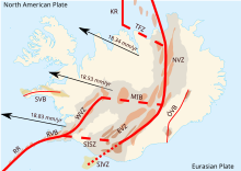
RR, Reykjanes Ridge; RVB, Reykjanes Volcanic Belt; WVZ, West Volcanic Zone; MIB, Mid-Iceland Belt; SISZ, South Iceland Seismic Zone; EVZ, East Volcanic Zone; SIVZ, South Iceland Volcanic Zone; NVZ, North Volcanic Zone; TFZ, Tjörnes Fracture Zone; KR, Kolbeinsey Ridge; ÖVB, Öræfajökul Volcanic Belt; SVB, Snæfellsnes Volcanic Belt.