Voyageur Hiking Trail
The trail dates to 1973, and is a work in progress that has involved hundreds of volunteers, private sector and government supporters.
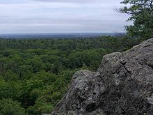
The hiking trail crosses the vast privately and publicly owned forests of this rugged wilderness.
The route parallels these two great bodies of water, frequently touching on the shoreline or affording glimpses from distant promontories.
While most of the trail has been built and maintained by volunteer members, portions within Provincial and Federal Park lands have been included with the consent of those agencies.
The Voyageur Trail Association was created as a not-for-profit entity; individual club members are responsible for maintaining the footpaths within their areas.
Planning of the Voyageur Hiking Trail began on March 23, 1973 when the then Commissioner of Parks and Recreation for the City of Sault Ste.
Marie, Harold Brain, convened a meeting of ‘persons interested in establishing a hiking trail along the precipice of the Cambrian Shield’ from Gros Cap on Lake Superior to Hiawatha Park, just north of Sault Ste.
Marie forest research scientist and member of the Bruce Trail Association, immediately saw the possibility of extending this concept to extend northward to Thunder Bay and eastward to Espanola, then south across Manitoulin Island to link up with southern Ontario’s Bruce Trail.