Military roads of Scotland
The roads were constructed to link the Central Lowlands with a series of fortified barracks located strategically across the Highlands.
Their purpose, much like the network of roads constructed by the Romans more than 1,500 years earlier, was to suppress and exert control over the local population.
In his report Wade pointed out that government troops would benefit from improved roads and river crossings to put down the rebels.
Wade engaged craftsmen with skills in masonry, carpentry, for example, to ensure that major structures such as bridges were built to a standard.
The well-known Kingshouse on Rannoch Moor sits beside the route made by Wade's successor William Caulfeild.
After crossing the River Spey the road ran along the western side of Strathspey via Kincraig, Alvie and Aviemore to Kinveachy.
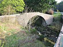
He chose to cross the River Nairn at Bridge of Faillie before running the road a last few miles over Drummossie Muir to the barracks at Fort George, Inverness.
The bridge spanning the River Tay at Aberfeldy and designed by William Adam, proved to be the single most expensive structure on the whole network, exceeding £4000 on its completion in 1734 some years after the remainder of the road.
From Aberfeldy the route turned west along Strath Tay and then northwest beside the River Lyon before breaking northwards beside the Keltney Burn and Glen Goulandie heading for a crossing of the River Tummel at Tummel Bridge - a route approximated by the modern B846 road.
The road ran northwest from the bridge and around Drumcroy Hill to the remote hamlet of Trinafour and a crossing of the Errochty Water.
[11] The initial part of the route which runs north from Dalwhinnie consists of numerous straight sections; its many sharp bends contribute to the reputation of the modern A889 road which follows it, as one of the most dangerous in Scotland.
The connecting route from Ruthven ran west from the barracks through the upper part of Strathspey initially south of the river but then crossing it at Garva Bridge.
[12] Ironically this road may have served the Jacobite forces more effectively than government troops, since during the 1745 rebellion after Prince Charles Edward Stuart raised his standard at Glenfinnan he used it to move fairly rapidly to Perth and the Lowlands.
Its 44 miles (71 km) which took it via the western side of Loch Lomond, Tarbet, Arrochar and Glen Croe were not then completed until 1749.
A stone seat was erected at the summit of the 860-foot-high (260 m) pass at the head of Glen Croe bidding travellers to Rest and be thankful, hence the modern name.
[20] Caulfeild engineered the road through the West Highlands from Fort Augustus to Bernera Barracks in 1755 but Telford’s commissioners remade it in the 1820s.
It initially headed west through Inchnacardoch Forest climbing to a height of over 1,280 feet (390 m) before dropping into Glen Moriston.
[21] From Braemar a road was constructed eastwards down the Dee valley, crossing the river at Invercauld Bridge and continuing to the north bank to a point opposite Balmoral Castle.
The road bridged the River Gairn at Gairnshiel and continued northwards over a high pass to Corgarff Castle in the upper part of the Don valley.
The road passed through or by Dumfries, Haugh of Urr, Castle Douglas, Bridge of Dee, Gatehouse of Fleet, Creetown, Newton Stewart, Glenluce and Stranraer.
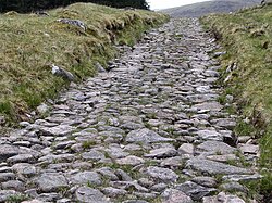
[27] The highland road building programme ceased with Caulfeild's death in 1767 with some 1,100 miles (1,800 kilometres) having been constructed.
As the Jacobite threat receded towards the end of the 18th century so the need for upkeep of the roads for military purposes diminished.
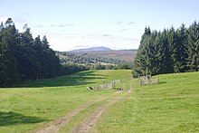
Miles of former road can now be traced stretching across country, either completely abandoned or serving as estate tracks or paths for walks and mountain bikers.