Waikato River
It then drains Taupō at the lake's northeastern edge, creates the Huka Falls, and flows northwest through the Waikato Plains.
[4][5] The Waikato River has spiritual meaning for various local Māori tribes, including the large Tainui, who regard it as a source of their mana, or pride.
After the huge Oruanui eruption 27,000 years ago ignimbrite was showered all over the North Island to a thickness of 200 metres (660 ft).
The water accumulated until a new outlet was forced 120 metres (390 ft) above the present lake level, near Waihora Bay.
Then the original, blocked outlet suddenly gave way; the lake level fell 75 metres (246 ft) as about 80 cubic kilometres (19 cu mi) of water and debris poured out in a catastrophic breakthrough flood causing the river to change course near Piarere.
The water level dropped quickly and the river stayed in this new course through the Maungatautari gorge and Hamilton Basin.
[20] In prehistoric times, the Waikato's course has occasionally shifted to flow north through the Hinuera Gap into the Firth of Thames and from there into the Hauraki Gulf / Tīkapa Moana.
[21] The river's current course is largely the result of the massive Hatepe eruption of the Taupō Volcano in 180 AD.
[22] The mean discharge of the Waikato River is 340 cubic metres per second (12,000 cu ft/s), with the highest flows typically occurring in July and August.
[25] Taupō, Mangakino, Cambridge, Hamilton, Horotiu, Ngāruawāhia, Huntly, Hampton Downs, Meremere, Waiuku and Port Waikato are on or close to it.
The river was of military importance in the land wars between New Zealand settler and Kingitanga forces during 1863–64 and significant battles were fought.
Three shallow draft gunboats were designed in New Zealand and built in Sydney in kitset form; the hulk of the paddle steamer Rangiriri is preserved at Hamilton.
A cemetery containing the graves of the British military dead can be found at Rangiriri opposite the hotel, shops and cafe.
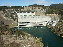
The power scheme begins at Lake Taupō, which has control gates to regulate the flow of water into the river.
[28] On its journey downstream it passes through power stations at Aratiatia, Ohakuri, Atiamuri, Whakamaru, Maraetai, Waipapa, Arapuni and Karapiro.
[33] The Waikato is renowned among whitewater kayaking enthusiasts, specifically for the Full James rapid located north of Taupō.
There are council boat ramps, run by Waikato District, Hamilton City, South Waikato District and Taupō District, at Port Waikato Rd; Hoods Landing Rd, Otaua; Elbow Rd, Aka aka; River Rd, Tuakau; Riverbank Rd, Mercer; Churchill East Rd, Rangiriri; Ohinewai Landing Rd; Boatie Reserve SH1, Parry St and Riverview Rd, Huntly; SH1 Taupiri; Waikato Esplanade, Ngāruawāhia;[36] Farm and Braithwaite Parks, Pukete; Swarbricks Landing, Hamilton Pde, Pine Beach, Ferrybank, Memorial Park, Roose Commerce Park, Hayes Paddock, Hamilton Gardens;[37] Narrows Lane, Tamahere;[36] Karapiro (6 ramps); Arapuni (4); Maraetai;[38] Whakamaru (3);[39] Ohakuri[38] and Mangakino.
[47] Several of the old steamers remain under, or beside the river,[48] including the Manuwai,[49] Rawhiti (built 1925)[50] and Freetrader on the west bank just south of Mercer.
[55] Public cruises operate from Aratiatia to Huka Falls,[56] across the river to Orakei Korako,[57] from Hamilton Gardens to Mystery Creek and Fairfield Bridge[58] and, since 2009,[59] from Tuakau to Port Waikato.
[60] On 19 July 2021 a ferry service began on the river in Hamilton,[61] linking Swarbrick's Landing and Braithwaite Park with the museum and gardens.
[73] Te Araroa (the walkway running the length of the country) follows the Waikato for most of its 80 kilometres (50 mi) between Mercer and Hamilton.
[75] The introduced species include rainbow and brown trout providing what has been called "the finest fly-fishing in the world".
The large catchment area of the Waikato River is highly fertile farmland, so intensive agriculture is present.
The mismanagement of nitrogen fertilizer and effluent spreading practices in dairy farming is seen as the major causes of this pollution.
Since 2000 Environment Waikato has joined with conservation minded farmers to bring about more efficient and scientific use of fertilizers.
The remnants of these can be seen in the silt channels carved out of what is now St Andrews golf course, adjacent to the river in Hamilton.
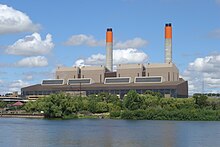
A further issue is industrial and metropolitan waste from early-established landfills and waste-emitting factories on the banks of the river.
The 2002 GHD report saw new regulations put in place to make industries comply with a new bylaw which stops hazardous substances entering the water system at all according to the HCC website.