Walking in London
In addition there are attractive commons, parks, canals, and disused railway tracks that provide space for walks.
Originally called the Silver Jubilee Walkway, and laid down in 1977 as part of the celebrations of the Silver Jubilee of Elizabeth II, the route takes in many of London's major attractions, including the Houses of Parliament, St Paul's Cathedral, Tate Modern and the Tower of London.
[11] In 2011 Lambeth Council passed a resolution to work towards creating a definitive map for the borough, but this does not yet exist.
Sir, if you wish to have a just notion of the magnitude of this city, you must not be satisfied with seeing its great streets and squares, but must survey the innumerable little lanes and courts.
It is not in the showy evolutions of buildings, but in the multiplicity of human habitations which are crowded together, that the wonderful immensity of London consists.
The coffeehouses[16] of Exchange Alley, especially Jonathan's and Garraway's, became an early venue for the lively trading of shares and commodities.
West of the City there are a number of alleys just north of Trafalgar Square, including Brydges Place, which is situated right next to the Coliseum Theatre and just 15 inches wide at its narrowest point, only one person can walk down it at a time.
It is the narrowest alley in London and runs for 200 yards (180 m), connecting St Martin's Lane with Bedfordbury in Covent Garden.
[17] An alley in London can also be called a passage, court, place, lane, and less commonly path, arcade, walk, steps, yard, terrace, and close.
The route forms a complete circuit, crossing the River Thames twice and with a notional starting point of Woolwich.
A 150-mile (240 km) circular signed walk, in 24 sections, along public footpaths, and through parks, woods and fields around the edge of Outer London.
The Dollis Valley Greenwalk (or Green Walk) is a footpath route in the London Borough of Barnet between Moat Mount Nature Reserve in Mill Hill and Hampstead Heath.
The path runs through the Lee Valley Regional Park, a 10,000-acre (40 km2), 26 miles (42 km) long linear park, much of it green spaces, running through the northeast of Greater London, Essex and Hertfordshire from the River Thames to Ware, through areas such as Stratford, Hackney, Tottenham, Enfield, Walthamstow, Cheshunt, Broxbourne and Hoddesdon in an area generally known as the Lea Valley.
A walking and cycle path has been created on the land above the eastern end of the Northern Outfall Sewer, from Hackney Wick to Beckton, Poplar, running some 4.5 miles (7.2 km), with access points along its length.
The Waterlink Way is a cycling and walking route in south-east London, following the River Ravensbourne (Deptford Creek) eight miles (13 km)[34] through Greenwich, Lewisham and Bromley boroughs.
A waymarked walk in south-east London, following the River Shuttle "for its entire length of five miles (about 8 km)" from Avery Park in Greenwich through Bexley to Hall Place Gardens.
[35] London's parks, heaths, and commons are crossed by numerous footpaths, both paved and unpaved, that provide walks of various lengths.
With increasing urbanisation of London, some of these were preserved as freely accessible open space and became public parks with the introduction of the Crown Lands Act 1851.
Kensington Gardens are generally regarded as being the western extent of the neighbouring Hyde Park from which they were originally taken, with West Carriage Drive (The Ring) and the Serpentine Bridge forming the boundary between them.
One of the Royal Parks of London, and the first to be enclosed (in 1433), it covers 74 hectares (180 acres),[56] and is part of the Greenwich World Heritage Site.
One of the main features of the park is the Long Water, which runs roughly eastward from the back of Hampton Court Palace.
The Wimbledon Common is for the benefit of the general public for informal recreation, and for the preservation of natural flora and fauna.
There is an area of bog, and the western slopes, which lie on London Clay, support mature, mixed woodland.
[23] This 10 miles (16 km) long route acts as a link between the Capital Ring, which runs just north of the Heath through Highgate, and the London Loop.
[22] The Heath is a grassy public space that sits astride a sandy ridge, which is one of the highest points in London, reaching 134 metres (440 ft).
[69] Running from Hampstead to Highgate, this ridge rests on a band of London Clay,[70] that embraces ponds, meadows, recent and ancient woodlands, a lido, playgrounds, and a training track, and it adjoins the stately home of Kenwood House and its grounds.
Running along the Heath's eastern perimeter are a chain of ponds – including three open-air public swimming pools – which were originally reservoirs for drinking water from the River Fleet.
[73] There is also a long-distance challenge walk that runs 21 miles (34 km), with views over Essex, Hertfordshire and London: a route "across dragonfly meadows, over small hills, past places associated with Queen Boadicea, through beech and oak forest where deer and fox roam".
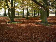
It contains areas of woodland, grassland, heath, rivers, bogs and ponds and is a Site of Special Scientific Interest.
The forest lies on a ridge between the valleys of the rivers Lea and Roding; its elevation and thin gravelly soil (the result of glaciation) historically made it unsuitable for agriculture.