Warbreck (ward)
A report of the Local Government Boundary Commission for England published in November 1978 set out proposals for changes to the wards of Liverpool City Council, maintaining the number of councillors at 99 representing 33 wards.
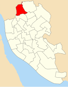
[1] The report describes the boundaries of Warbreck ward as "Commencing at a point where Breeze Hill meets the northwestern boundary of the City, thence generally northeastwards along said boundary to Roosevelt Drive, thence southeastwards along said drive to Helling Road, thence southwestwards along said road to the road known as Warbreck Moor, thence southwards along said road to Albany Road, thence eastwards along said road to Goodacre Road, thence southeastwards along said road to Longmoor Lane, thence southwestwards along said lane to Long Lane, thence southeastwards along said lane to Stopgate Lane, thence southeastwards along said lane to Charnock Road, thence southwestwards along said road to its end being the northeastern boundary of the Factory, thence northwestwards along said boundary and southwestwards along the northwestern boundary of said factory and in prolongation thereof to the northern boundary of Walton Hall Park, thence westwards and southwestwards along said northern boundary to a point due north of the northernmost corner of Hetherlow Towers, thence due south to said corner, thence generally southwestwards along the northern ,and western boundaries of Hetherlow Towers, the northwestern boundary of the Corporation Yard and the northwestern boundary of the Builder's Yard to Moor Lane, thence southwestwards along said lane to the road known as Queens Drive Walton, thence westwards along said road, North Breeze Hill and Breeze Hill to the point of commencement".
[2] A review by the Boundary Committee for England recommended that the council was formed of a reduced number of 90 members elected from 30 wards.
The ward contained HM Prison Liverpool, Hartley Village and was close to the Netherton area of Bootle.
There is also a "Warbreck" public house within the ward's boundaries situated on Orrell Lane.