Warehouse Precinct
Sited on reclaimed land at the northernmost tip of the Southern Endowment, it lies between 1 and 2 kilometres south of The Octagon, the city's centre.
No defined southern boundary exists for the precinct, though most of the current beautification schemes stretch as far as Police Street, 600 metres south of Queens Gardens.
Buildings within the Warehouse Precinct are of a variety of ages and styles, but many of them date from the late Victorian and Edwardian periods, with several of them showing the influence of Classical revival and Chicago school architecture.
Many of the city's older and more imposing buildings are located in the area, a large number of them built during and immediately after the Otago gold rush of the 1860s.
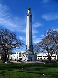
[11] Queens Gardens is a roughly triangular area of trees and lawn at the northern end of the Warehouse Precinct.
It is bounded by several major roads, among them the two one-way streets which form part of SH 1, one of which cuts through the westernmost tip of the Gardens.
Buildings within and adjacent to the Warehouse Precinct listed on the Heritage New Zealand register of historic places include the following: Other notable buildings include the Robert Lawson-designed Vogel House and Reid Wool Exchange, both in Vogel Street; former education board offices later used by A.H. and A.W.
From here it links with the city's inner wharves and with Portsmouth Drive, a major arterial route leading to Otago Harbour.
At the time the bridge was built, in the late 1970s, the rail yards were far more extensive, but in the final years of the 20th century some of the tracks were removed and part of the land was subdivided for wholesale and retail premises.