Wash Common
Towards the north west the main road climbs up a gentle incline from Newbury, and continues in a South Easterly direction down a rather steeper slope (once called Trundle Hill,[2] a name no longer used) towards Andover.
In 1858 an enclosure resolution was passed; W Money, author of "A Popular History of Newbury" published in 1905, describes this act in terms of a land grab, (see chapter XVI): "it is scarcely necessary to add that the householders of Newbury received no compensation when thus deprived of the valuable rights and privileges which had been enjoyed by the commonality of the town for so many centuries, but their inheritance was bestowed on their more favoured neighbours, whose only claim was that they were already possessed, by purchase or otherwise, of land within the boundaries of the borough".
The slope which the Parliamentarians captured, east of Skinners Green and including Round Hill, lies just outside the boundary of Wash Common itself.
The area where Prince Rupert's cavalry clashed with the Parliamentarians includes the present Wash Common recreation ground but is largely built over [ibid].
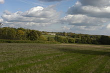
It is also famous as the birthplace of Richard Adams, the author of Watership Down, which begins in eastern Wash Common, specifically on the edge with the more rural and open region of Sandleford.