Washdyke Lagoon
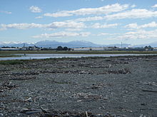
It is enclosed by a barrier beach that is 3 kilometres (1.9 mi) long and 3 metres (9.8 ft) above high tide at its largest point (see Figure 1).
The reduced lagoon size is due to the construction of the Timaru Port breakwater which is preventing coarse sediments from reaching and replenishing Washdyke Barrier.
This is important as the lagoon and the surrounding 250 hectares (620 acres) are classified as a wildlife refuge and it demonstrates the role human structures have on coastline evolution.
[2] Lagoons form when longshore transport builds up sediment across the mouth of a water source cutting it off or diverting it from directly reaching the ocean.
[1] The barriers created rely on the accretion of sediment to at least equal the rate of erosion in order for the lagoon to remain separate from the ocean.
[11] Southerly currents push them north and they are then deposited on Washdyke Barrier causing it to stay above the high tide mark and form the lagoon.
[12] Waituna Lagoon is also under threat from breaching but in this case it is machinery not erosion that is opening the coastal lake to the ocean.
The drastic reduction in area of the lagoon can be at least partially attributed to the construction of the Timaru Port, which started in 1878.
[14] In building the port's 700 metres (2,300 ft) long breakwater (Figure 3) the sediment supply from the south is blocked from reaching the Washdyke Lagoon area.
[1] As shown in Figure 4, prior to breakwater construction fine and coarse sediments were transported from the south and deposited on Washdyke Barrier.
However, after the breakwater was built the coarse sediment is unable to reach the barrier as it accumulates at the port's southern side.
Breakwaters and other man-made structures in Thailand are responsible for accelerated beach erosion which may start to affect tourism in the coming years.
[22] In Hallsands, Devon, England, a combination of an existing seawall and new gravel dredging to form a harbour from 1986 to 1902, caused the erosion of the whole village by 1917.
This was due to sediment starvation causing the erosion of the mixed sand and gravel barrier beaches which protected the village.
[23] More recently there has been concern about the pollution runoff from the Washdyke industrial area immediately to the west of the lagoon.
This pipe was constantly at risk to exposure and damage as the barrier eroded and would have contributed pollutants and caused nitrification in the lagoon.
Mixed sand and gravel barriers are an area that is being continuously studied and some long term behaviours are still not understood.
A challenge to future work is that the Timaru Port is a major economic driver in the region and sections of the community may feel that Washdyke Lagoon is a necessary sacrifice.
This will have ecological implications and will also allow for flooding of land previously protected by the lagoon, such as the Washdyke industrial area.