Water management in Victoria
Following droughts in the 1870s, the Water Conservation and Distribution Act 1881 was passed to help establish local waterworks trusts.
It allowed local trusts to borrow funds from the government for the construction of water supply works.
The trusts could then charge water rates to users in order to recoup their costs and pay the interest on the loans.
MMBW continued to augment Melbourne's water supply with diversions from upland tributaries of the Yarra River.
Silvan Reservoir was completed in 1932 to regulate the increased flows in the O'Shannassy Aqueduct from the Upper Yarra River and Coranderrk Creek diversions.
While the Upper Yarra Project was being built, a 1.7-metre diameter pipeline from a basin near Starvation Creek to Silvan Reservoir was completed in 1953.
In response to the severe drought of 1967–68: To improve transfer capacity between Upper Yarra and Silvan reservoirs, and to enable water harvested from the Thomson River to be transferred to Cardinia Reservoir, the 2.1-metre diameter Yarra Valley Conduit and Silvan-Cardinia main were built in 1975.
The final stage of the Thomson project concluded in May 1983 with an extension of the Thomson-Yarra Tunnel and completion of the dam wall.
The Sugarloaf Reservoir Project, including a major pumping station and water treatment plant, was completed in 1981, increasing Melbourne's total storage capacity by 95,000 megalitres.
The regional catchment strategy can also undertake to provide incentives to landholders, educational programs, research and other services.
[10] Several pipelines have also been constructed in an effort to link regional systems to facilitate the trading of water.
Since 2016, water pricing has been based on the PREMO incentive mechanism, which focuses on five elements: performance, risk, engagement, management and outcomes.
The PREMO framework seeks to link reputation and financial outcomes to the level of ambition in a water business’s price proposal.
It also holds water businesses accountable for the actions and decisions they make and for delivering the service outcomes proposed.
The border also rests at the southern end of the Great Dividing Range, which stretches along the east coast and terminates west of Ballarat.
The official border between Victoria and Tasmania is at 39°12' S, which passes through Boundary Islet in the Bass Strait for 85 metres.
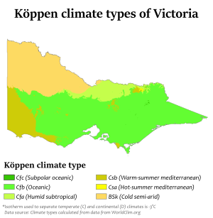
Victoria's main land feature, the Great Dividing Range, produces a cooler, mountain climate in the centre of the state.
The Mallee and upper Wimmera are Victoria's warmest regions with hot winds blowing from nearby semi-deserts.
Victoria's highest maximum temperature of 48.8 °C (119.8 °F) was recorded in Hopetoun on 7 February 2009, during the 2009 southeastern Australia heat wave.
The Alps are part of the Great Dividing Range mountain system extending east–west through the centre of Victoria.
Victoria's highest recorded daily rainfall was 377.8 mm (14.87 in) at Tidal River in Wilsons Promontory National Park on 23 March 2011.