Waterford, California
Waterford is the eighth largest city in Stanislaus County, California, United States.
City population signs report Waterford's elevation is 51 feet (16 m) above sea level.
Due to its proximity to the Sierra foothills, Waterford tends to have 1-2 degree cooler average temperatures than its neighboring Central Valley cities like Modesto and Turlock, which are more in the depths of the valley.
305 households (12.4%) were made up of individuals, and 106 (4.3%) had someone living alone who was 65 years of age or older.
There were 2,665 housing units at an average density of 1,125.1 per square mile (434.4/km2), of which 1,627 (66.2%) were owner-occupied, and 831 (33.8%) were occupied by renters.
11.4% of all households were made up of individuals, and 5.2% had someone living alone who was 65 years of age or older.
The community which became Waterford began to form in the latter half of the 19th century, after surrounding regions became populated with 49ers.
It soon became apparent that mail was being mistaken between Bakersville and Bakersfield, California, and the smaller of the two was forced to change its name.
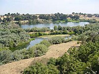
At that time, the Tuolumne River did not have a bridge, and instead was crossed by Roberts Ferry on the waterfront.
For several decades, a regular steam locomotive could traverse the Tuolumne in Waterford on a trestle bridge, which was demolished in the second half of the 20th century.
There are now no longer railway lines running through or near Waterford, even though many maps will still show the tracks going through the post office building.
The city is served by Stanislaus Regional Transit Authority bus service.
Waterford has two main highways: CR J9, "F Street", and State Route 132, "Yosemite Blvd."
It is the only bridge for about 5 miles (8.0 km) both east and west to cross the Tuolumne River after Geer Road.