National Weather Service
It is a part of the National Oceanic and Atmospheric Administration (NOAA) branch of the Department of Commerce, and is headquartered in Silver Spring, Maryland, within the Washington metropolitan area.
On February 9, 1870, the first official weather service of the United States was established through a joint resolution of Congress signed by President Ulysses S. Grant[13] with a mission to "provide for taking meteorological observations at the military stations in the interior of the continent and at other points in the States and Territories... and for giving notice on the northern (Great) Lakes and on the seacoast by magnetic telegraph and marine signals, of the approach and force of storms."
The agency was placed under the secretary of war as Congress felt "military discipline would probably secure the greatest promptness, regularity, and accuracy in the required observations.
[16] Throughout his career with the weather service, which lasted 45 years, Abbe urged continued research in meteorology to provide a scientific basis for forecasting.
Robert C. Miller and Major Ernest Fawbush) beyond military personnel that the Bureau issued its first experimental public tornado forecasts in March 1952.
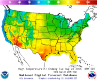
[31] The NDFD is a collection of common weather observations used by organizations and the public, including precipitation amount, temperature, and cloud cover among other parameters.
The appropriate crews use this information to plan for staffing and equipment levels, the ability to conduct scheduled controlled burns, and assess the daily fire danger.
[35] IMETs are NWS forecasters specially trained to work with Incident Management Teams during severe wildfire outbreaks or other disasters requiring on-site weather support.
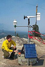
The kit includes a cell phone, a laptop computer, and communications equipment, used for gathering and displaying weather data such as satellite imagery or numerical forecast model output.
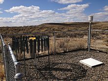
Remote weather stations are also used to gather specific data for the point of interest,[35] and often receive direct support from the local WFO during such crises.
IMETs, approximately 70 to 80 of which are employed nationally, can be deployed anywhere a disaster strikes and must be capable of working long hours for weeks at a time in remote locations under rough conditions.
SPC compiles reports of severe hail, wind, or tornadoes issued by local WFOs each day when thunderstorms producing such phenomena occur in a given area, and formats the data into text and graphical products.
If a tropical cyclone threatens the United States or its territories, individual WFOs begin issuing statements detailing the expected effects within their local area of responsibility.
The NHC and CPHC issue products including tropical cyclone advisories, forecasts, and formation predictions, and warnings for the areas in the Atlantic and parts of the Pacific.
Their mission is to "serve the public by assessing and forecasting the impacts of short-term climate variability, emphasizing enhanced risks of weather-related extreme events, for use in mitigating losses and maximizing economic gains."
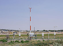
A small, expendable instrument package is suspended below a 2 metres (6.6 ft) wide balloon filled with hydrogen or helium, then released daily at or shortly after 1100 and 2300 UTC, respectively.
When the balloon has expanded beyond its elastic limit and bursts (about 6 m or 20 ft in diameter), a small parachute slows the descent of the radiosonde, minimizing the danger to lives and property.
Warnings for severe local storms are intended to be issued preceding the arrival of severe weather at a particular locale by one hour or less; the NWS also issues warnings and advisories for various hydrological and non-hydrological events including floods, non-thunderstorm high winds, winter storms, intense heat or cold, fire weather and marine hazards, which vary in timepsan depending on the weather situation (inland and coastal warnings for tropical cyclones are issued by the National Hurricane Center (NHC), a guidance center of the National Oceanic and Atmospheric Administration).
"[46][47] In earnest, they indicate that hazardous weather conditions are occurring that may pose a risk to life and property, and are intended to direct the general public to take immediate action and heed safety precautions; it also has the side purpose of directing emergency management personnel to be on standby in case the weather situation leads to property damage or casualties.
[48] The process of issuing a warning or advisory begins with observations of a hydrological or extreme weather event that is either occurring at present (through radar imagery, reports from local television and radio stations, or ground observations by local law enforcement, civil defense officials, media outlets or storm spotters) or is forecast to occur within 12 to 24 hours.
For local storm events, the warning or advisory product also outlines a meteorological summary of the most recent storm location or local storm report issued prior to the product's issuance (including the approximate area in statute miles and estimated speed and direction), associated hazards, impacts, municipalities and designated land areas (and, if applicable, highway mile markers) covered by the alert, and boilerplate action messages informing the public of safety precautions they need to take or advising them to be vigilant of any warnings or weather statements that may be issued by their local National Weather Service office.
In April 2012, the NWS introduced the Impact Based Warning system at its Weather Forecast Offices in Wichita and Topeka, Kansas, and Springfield, St. Louis and Kansas City/Pleasant Hill, Missouri; the pilot project – which would expand to 80 Weather Forecast Offices overseen by the Central, Eastern, Southern and Western Region Headquarters by the spring of 2015 – incorporate message tags within the main body of the product describing the source of the hazard report, damage potential, and if applicable, radar indications or physical observations of tornadoes or the possibility of a tornado; hazards are also summarized at the close of the product text (describing estimated maximum hail size and wind gusts, and if applicable, if a storm has the potential to produce a tornado or in the event of a tornado warning, the basis of the warning or its damage threat).
[50][51][52][53] The wording "Particularly Dangerous Situation" (PDS), which originated by the Storm Prediction Center for use in tornado watch products during expected high-end severe weather outbreaks, is subjectively issued.
[54] Until September 30, 2007, local offices of the National Weather Service issued warnings for severe thunderstorms, tornadoes, flash flooding and marine hazards using geopolitical boundaries.
Its purpose is to provide state and federal government, commercial users, media and private citizens with timely delivery of meteorological, hydrological, climatological and geophysical information.
NWWS delivers severe weather and storm warnings to users in ten seconds or less from the time of their issuance, making it the fastest delivery system available.
Also offered are XML data feeds of active watches and warnings, ASOS observations and digital forecasts for 5x5 kilometer (3 x 3 mile) grids.
[64] National Weather Service forecasts and data, being works of the federal government, are in the public domain and thus available to anyone for free under United States law.
Groups such as the Aircraft Owners and Pilots Association condemned the bill's restrictions on weather forecasting as threatening the safety of air traffic, noting that 40% of all aviation accidents are at least partially weather-related.
In 2016, the British Met Office, the European Centre for Medium-Range Weather Forecasts (ECMWF), and the Northwest Regional Modeling Consortium in Seattle have been cited as producing more accurate predictions in certain circumstances.