Weather forecasting
[4] Chinese weather prediction lore extends at least as far back as 300 BC,[5] which was also around the same time ancient Indian astronomers developed weather-prediction methods.
"[7] In 904 AD, Ibn Wahshiyya's Nabatean Agriculture, translated into Arabic from an earlier Aramaic work,[8] discussed the weather forecasting of atmospheric changes and signs from the planetary astral alterations; signs of rain based on observation of the lunar phases; and weather forecasts based on the movement of winds.
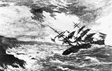
The two men credited with the birth of forecasting as a science were an officer of the Royal Navy Francis Beaufort and his protégé Robert FitzRoy.
Both were influential men in British naval and governmental circles, and though ridiculed in the press at the time, their work gained scientific credence, was accepted by the Royal Navy, and formed the basis for all of today's weather forecasting knowledge.
[15][16] Beaufort developed the Wind Force Scale and Weather Notation coding, which he was to use in his journals for the remainder of his life.
Robert FitzRoy was appointed in 1854 as chief of a new department within the Board of Trade to deal with the collection of weather data at sea as a service to mariners.
[17] Fifteen land stations were established to use the telegraph to transmit to him daily reports of weather at set times leading to the first gale warning service.
[19] Instruments to continuously record variations in meteorological parameters using photography were supplied to the observing stations from Kew Observatory – these cameras had been invented by Francis Ronalds in 1845 and his barograph had earlier been used by FitzRoy.
In 1922, English scientist Lewis Fry Richardson published "Weather Prediction By Numerical Process",[22] after finding notes and derivations he worked on as an ambulance driver in World War I.
He described therein how small terms in the prognostic fluid dynamics equations governing atmospheric flow could be neglected, and a finite differencing scheme in time and space could be devised, to allow numerical prediction solutions to be found.
However, the sheer number of calculations required was too large to be completed without the use of computers, and the size of the grid and time steps led to unrealistic results in deepening systems.
[23] The first computerised weather forecast was performed by a team composed of American meteorologists Jule Charney, Philip Duncan Thompson, Larry Gates, and Norwegian meteorologist Ragnar Fjørtoft, applied mathematician John von Neumann, and ENIAC programmer Klara Dan von Neumann.
[30][34] In the late 1970s and early 1980s, John Coleman, the first weatherman for the American Broadcasting Company (ABC)'s Good Morning America, pioneered the use of on-screen weather satellite data and computer graphics for television forecasts.
[48][49] Reconnaissance aircraft are also flown over the open oceans during the cold season into systems that cause significant uncertainty in forecast guidance, or are expected to be of high impact three–seven days into the future over the downstream continent.
This can be in the form of statistical techniques to remove known biases in the model, or of adjustment to take into account consensus among other numerical weather forecasts.
This guidance is presented in coded numerical form, and can be obtained for nearly all National Weather Service reporting stations in the United States.
In numerical models, extremely small errors in initial values double roughly every five days for variables such as temperature and wind velocity.
High thin cirrostratus clouds can create halos around the sun or moon, which indicates an approach of a warm front and its associated rain.
[71] However, there are now expert systems using those data and mesoscale numerical model to make better extrapolation, including evolution of those features in time.
It remains a useful method of observing rainfall over data voids such as oceans,[78] as well as the forecasting of precipitation amounts and distribution in the future.
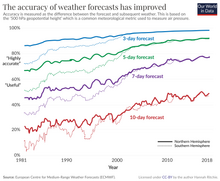
In 2024, AIFS started to publish real-time forecasts, showing specific skill at predicting hurricane tracks, but lower-performing on the intensity changes of such storms relative to physics-based models.
[81] Microsoft's Aurora system offers global 10-day weather and 5-day air pollution (CO2, NO, NO2, SO2, O3, and particulates) forecasts with claimed accuracy similar to physics-based models, but at orders-of-magnitude lower cost.
Thunderstorms can create strong winds and dangerous lightning strikes that can lead to deaths, power outages,[86] and widespread hail damage.
[88] Excessive heat or cold waves can sicken or kill those with inadequate utilities, and droughts can impact water usage and destroy vegetation.
Several countries employ government agencies to provide forecasts and watches/warnings/advisories to the public to protect life and property and maintain commercial interests.
[100] On a day-to-day basis airliners are routed to take advantage of the jet stream tailwind to improve fuel efficiency.
[103] Commercial and recreational use of waterways can be limited significantly by wind direction and speed, wave periodicity and heights, tides, and precipitation.
[114] The British Royal Navy, working with the Met Office, has its own specialist branch of weather observers and forecasters, as part of the Hydrographic and Meteorological (HM) specialisation, who monitor and forecast operational conditions across the globe, to provide accurate and timely weather and oceanographic information to submarines, ships and Fleet Air Arm aircraft.
The United States Navy provides a special service for itself and the rest of the federal government by issuing forecasts for tropical cyclones across the Pacific and Indian Oceans through its Joint Typhoon Warning Center.
[119] All four of the mentioned military branches have their initial enlisted meteorology technical training at Keesler Air Force Base.