Wester Ross
[4] Wester Ross has one of the lowest population densities in Europe, with just 1.6 people per km2, who live mostly in small crofting townships along the coastline of the region.
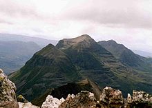
[11] Scenic spots including Loch Maree, Inverewe Garden, Corrieshalloch Gorge, Glen Docherty and the Bealach na Bà.
This new-style biosphere, which covers an area over 100 times larger than the original designation, is a place where people live and actively learn about their surroundings to inspire a legacy rich in both natural and cultural heritage.
Four services a day operate on the line, calling at stations at Achnasheen, Achnashellach, Strathcarron, Attadale, Stromeferry, Duncraig, Plockton and Duirinish, terminating at Kyle of Lochalsh.
[21] Despite being located at a latitude of between 57.2° and 58.0° North Wester Ross experiences a relatively mild maritime climate (Köppen Cfb) due to the influence of the Gulf Stream.
[25] The Mesolithic people were largely nomadic, and permanent settlements were first built during the Neolithic era, when trees were felled to create land for farming.
[27] From the 8th century Wester Ross, along with much of the western seaboard of Scotland, came under Norse domination, and placename evidence suggests that the Pictish language seems to have been entirely replaced wherever the Norsemen encountered it, with most names considered likely to be of Medieval rather than pre-Norse origin.
[citation needed] During this period the area was farmed under the communal run-rig system, with people living in small townships, growing oats, bere (barley), and later potatoes.
This trade expanded during the early 19th century, due to the demands of the new industrial cities and the British armed forces for cattle for beef.
During the late 18th and 19th centuries, the Highland Clearances saw tenants being forcibly moved to become crofters, a system under which their labour would be available when required by their landlords: they would be workers first and farmers second.
[30] In the later stages of the clearances the driver ceased to be industrial enterprises, but simply to clear the land for sheep farming, and later deer forests.
The area forms one of the Watsonian vice-counties, geographical divisions of the British Isles used for the purposes of biological recording and other scientific data-gathering.
[37] The rivers and lochs of Wester Ross support important populations of Atlantic salmon and sea trout, although numbers of adult fish have declined in recent years.
[39] The lochs also support internationally important concentrations of breeding black-throated divers, which is at the southern edge of its range in Wester Ross.
[39] There are areas of Caledonian pinewood at Shieldaig, Coulin, Torridon, Beinn Eighe, Rhidorroch, Achnashellach and the islands on Loch Maree.
Though small in terms of area, these pinewoods (which are composed chiefly of Scots pine, alongside deciduous species such as birch and rowan) are an internationally important habitat.
The moors are characterised by blanket bogs composed of sphagnum mosses, and host breeding birds such as golden plover, greenshank and dunlin, along with a resident population of red grouse.
[47] In 2014 59,900 hectares (599 km2) of coastal waters in the northern part of Wester Ross (from Rubha Rèidh to Coigach) was declared a Nature Conservation Marine Protected Area (NCMPA).
[5] Wester Ross has historically been a Gaelic-speaking area; however, the language suffered from persecution for many years, and its decline was hastened when English-language schooling became compulsory in the late 19th century.
[70][71] Many other songs refer to or are named after areas, geographical features and villages of Wester Ross, notably Loch Maree Islands, which has been recorded by many artists including Calum Kennedy.
[citation needed] American author George R. R. Martin took the name of the fictional continent in his epic fantasy franchise A Song of Ice and Fire, Westeros, from Wester Ross.