Whiskey Bottom Road
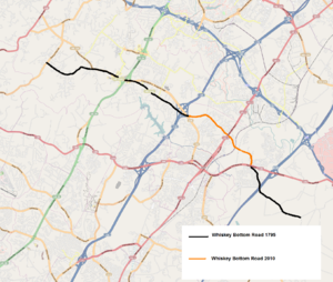
Starting from the northwest to the southeast: Whiskey Bottom Road maintains its original historical path and name until meeting with Maryland route 198 in Anne Arundel County.
[10] In a passage from the book The founders of Anne Arundel and Howard Counties, Maryland, the author cites letters describing the conflict between the Native Americans and the new settlers of the area...
In 1681, Robert Proctor, from his town on the Severn, Thomas Francis, from South River and Colonel Samuel Lane, from the same section, all wrote urgent letters stating that the Indians had killed and wounded both Negroes and English men "at a plantation of Major Welsh's," and "had attempted to enter the houses of Mr. Mareen Duvall and Richard Snowden.
In the 1950s, inn owner Albert L. Dalton posted a sign along Route 1 which read "Historical Whiskey Bottom Road—Circa 1732 A.D."[12] The majority of the modern road falls within "Robinhood's Forest", a land grant between Laurel and Sandy Spring, Maryland that was part of the accumulated 10,500-acre (42 km2) Birmingham Manor estate of the Snowden family starting in 1669 with a 500-acre (2.0 km2) patent purchased in exchange for 1,100 lb (500 kg) of tobacco.
[13] A 1795 map of Anne Arundel County by Dennis Griffith[14] shows the unnamed path that is now known as Whiskey Bottom Road starting at the Ridgley Farm in Highland, Maryland, passing south of Whites Mill in Savage, Maryland and terminating at the original Birmingham Manor site in South Laurel.
Despite the name, Whiskey Bottom follows the highest elevation between rivers to either side, making it the least prone path to flooding or muddy conditions.
The Native American trails were not paved or marked, but were commonly cleared regularly of underbrush and saplings by controlled fires, creating wide corridors lined only with mature trees up to six feet in diameter.
Overlook Farm was built on the site; its operators would later account that they would roll tobacco product down Whiskey Bottom Road in barrels toward the Patuxent for shipping.
[33] In 1736, roadside residents Richard Snowden III "Ironmaster" (1688–1763), Joseph Cowman, and three other partners founded "Patuxent Iron Work Company", Maryland's first ironworks.
Typical crops that they would plant were butter beans and sugar corn, radishes, beets, eggplant, tobacco, and apple trees.
181 acres of mixed farm and forest that formed the crossroads with Whiskey Bottom and the Washington Turnpike were sold by the company to John Holland in 1841.
[42] The violence escalated in November when John Watson and William Messer were murdered at the construction site around Whiskey Bottom.
[44] Born in Montgomery County, Gustavus Ober was a prominent Presbyterian Sunday School teacher at All Saint's church and owned several properties along Whiskey Bottom Road.
[46][47][48] The Bacontown community along the Anne Arundel portion of Whiskey Bottom Road was established by the freed slave Maria Bacon.
[51] United States postal mail started service to residents of "Whiskey Bottom Road" from the Laurel post office in 1899.
[53] A 1-mile (1.6 km) dirt oval racetrack once operated in the early 20th century at the southeast corner of Whiskey Bottom and Brock Bridge Roads.
[54] During prohibition, the road hosted speakeasies with houses outfitted with hidden rooms and liquor storage in the walls to hide supplies from stills along the Hammond Branch river (Patuxent).
[60] On the northwest corner of U.S. Route 1 and Whiskey Bottom Road, Crickett's California Inn hosted live bands from the 1960s until its relocation in 2008.
[citation needed] In 1958, Melville W. Beardsley founded National Research Associates company and settled on Whiskey Bottom Road in 1961.
The project has been supported by local leaders and community groups, with some criticism over the environmental impact, effect on adjoining properties, and the safety of the road entrance.
One resident's recollection from the late 1800s noted the "Maryland Rye" distillery was near the Laurel Mill, which used wagons to get the product to "Whiskey Bottom".
[18] Name change efforts were publicized as far away as Florida in an Ocala Star-Banner newspaper article from May 3, 1955, titled "Battle of Whiskey Bottom Road Rages".
Resident W.R. Shauck complained to the press that he was told by a realtor that he was on Old Annapolis Road when he purchased the land a decade earlier, and it had to be changed.
"[18] In October 1962, the Laurel Planning and Redevelopment Corporation gave Howard County 27 acres of woodland to build the Whiskey Bottom Road Elementary School within a proposed high-density development seeking zoning approval.
The heavily traveled Baltimore-Washington corridors that Whiskey Bottom Road crosses have been the site of fatal accidents since automobiles were introduced.
A steep curving bridge was first built over the railroad tracks reducing train collisions, but occasionally creating its own hazardous driving conditions.
[94] Howard County planned to follow suit in 2002 but opted to explore traffic calming after 98% of roadside residents petitioned against widening the road.
A series of narrow choking islands, and roundabouts were placed along the roadway with the intention of physically restricting the maximum speed of a vehicle to the 30 mph (48 km/h) limit.
Newsworthy crime incidents provide a historical context of this quiet rural road's transition to a dense suburban thoroughfare.
[113] In the 2006 fiction book, Borrow Trouble by Mary Monroe and Victor McGlothin, the character Franchetta wound up in a small tick on the map called "Whiskey Bottom, Maryland" at the age of 18 hawking boxes of popcorn.