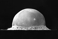
White Sands Missile Range
As the largest military installation in the United States, WSMR encompasses almost 3,200 sq mi (8,300 km2) including parts of Doña Ana, Otero, Socorro, Sierra, and Lincoln counties in southern New Mexico.
U.S. Highway 380 runs east-west along the northern edge of WSMR between San Antonio and Carrizozo, and is also subject to periodic closures during test firings.
New Mexico State Road 525 provides access from U.S. Highway 380 to the north end of WSMR near Stallion Army Airfield.
The 1972 DoD Centers for Countermeasures (CCM) evaluates precision guided munitions and other devices in electronic counter- and counter-countermeasures environments.
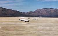
[23] Other operations on WSMR land include the Launch Abort Flight Test Complex for the Pad Abort-1, the White Sands Launch Complex 37 built for Nike Hercules tests, the White Sands Launch Complex 38 built for Nike Zeus tests with Launch Control Building now used for Patriot missile firings, the North Oscura Peak facility of the Air Force Research Laboratory Directed Energy Directorate, and the 1963 NASA White Sands Test Facility's ground station for Tracking and Data Relay Satellites, and the SDO ground station with two 18 m (59 ft) antennas.