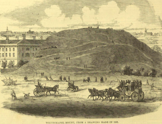
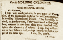
Whitechapel Mount
It was crossed by tracks, served as a scenic viewing-point (and a hiding place for stolen goods), could be ascended by horses and carts, and supported some trees and formal dwelling-houses.
Because Londoners widely believed in the "Great Fire rubble" theory, the remains were sifted by antique hunters, and some sensational finds were claimed.
[2] Leaving London, a traveller would pass the church of St Mary Matfelon (origin of the name "white chapel") on the right, then a windmill, before arriving at the Mount.
[10] Whitechapel Mount's position is first depicted in a 1673 building plan by Sir Christopher Wren, where he refers to it as "the mud wall called the Fort".
In John Rocque's map of London (1746) it has been horizontally truncated, but is shown with substantial elevation, with at least one dwelling-house – if not a terrace of houses – on its western end.
In Richard Blome's map of 1755 it has a large dwelling-house with front drive and appears alongside the newly built London Hospital.
In John Cary's 1795 map its western portion has been truncated by the newly built New Road, but appears to have a substantial building in its northwest corner.
In 1643 London was hastily fortified against the Royalist armies, for "there is terrible news that [Prince] Rupert will sack it and so a complete and sufficient dike and earthern wall and bulwarks must be made".
[18] The Scottish traveller, who inspected it, said it was a "nine angled fort only pallosaded and single ditched and planted with seven pieces of brazen ordnance [brass cannon], and a court du guard [guardhouse] composed of timber and thatched with tyle stone as all the rest are".
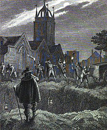
[26] Those willing to man the dead carts (and dispose of the corpses) were not fastidious; a contemporary said they were ‘very idle base liveing men and very rude", drawing attention to their task by swearing and cursing.
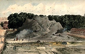
The clearest reputable source is the author Joseph Moser, who wrote In the course of last summer [1802], when part of the rubbish of [Whitechapel Mount] had just been removed, I had the curiosity to inspect the place, and observed in the different strata a great number of human bones, together with those, apparently, of different animals, oxen, or cows, and sheep’s horns, bricks, tiles, &c. The bones and other exuvia of animals were in many places, especially towards the bottom, bedded in a stiff, viscid earth, of the blueish colour and consistence of potter's clay, which was unquestionably the original ground, thrown into different directions, as different interments operated upon its surface.
William Guy who investigated the laystalls of mid-19th century London reported In most of the laystalls or dustmen's yards, every species of refuse matter is collected and deposited:– nightsoil, the decomposing refuse of markets, the sweepings of narrow streets and courts, the sour-smelling grains from breweries, the surface soil of the leading thoroughfares, and the ashes from the houses.
In all these establishments the bulk of the deposits consists of dust from the houses, which is sifted on the spot by women and boys seated on the dust-heaps, assisted by men who are engaged in filling the sieves, sorting the heterogeneous materials, or removing and carting them away.
[43]While the legislation speaks of "dung, soil, filth and dirt", most domestic refuse (by volume) comprised household dust[44] typically coal ash – hence the expression "dustman" – and this could be used for making bricks.
[45] At the close of the 18th century there was a tremendous demand for bricks to build the rapidly expanding London; "At night, a 'ring of fire' and pungent smoke encircled the City"; there were numerous local brickfields e.g. at Mile End.
[47] The construction of the East and West India Docks early in the nineteenth century caused roads to be made through the low marshy fields extending from Shadwell and Ratcliff to Whitechapel.
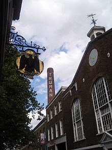
[49] The soil of the Mount was used to make bricks, see above, and these were delivered to e.g. Wentworth Street, Bethnal Green and "Hanbury's Brewhouse"[47] (the Black Eagle Brewery), buildings that stand today.
Mackinder (1994), London Hospital Medical College, Newark Building, Grid Reference TQ3456815: Evaluation produced evidence of a deep cut feature on the alignment of the English Civil War defences.
A large quantity of post-medieval red ware sugar cone moulds and collecting jars were recovered from the infilling of the ditch and later levelling of the site.
Extensive fill deposits may indicate quarrying, which took place after a successful petition to flatten the Mount fort by the hospital authorities at the end of the 18th century.
[58] The Coachman, a popular 18th century song,[59] began I'm a boy full spunk, and my name's little Joe, It's I that can tip the long trot; From Whitechapel-mount up to fam'd Rotten-row, With the ladies sometimes is my lot.