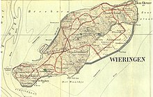
Wieringen
By 1200 it was an island, also named Wieringen, separated from the mainland during one of the severe storm floods in the late Middle Ages that changed the coastline.
In 2003 the provincial and local governments announced a project to restore Wieringen as an island by creating a recreational lake to be called the Wieringerrandmeer.
The landscape of Wieringen is not all flat: it is characterised by boulder clay mounds, formed during the Saale Ice Age.
It appears that at that time Texel and Wieringen islands were much larger and spread across what is now the western end of the Waddenzee and perhaps also other areas which are now sea or in polders.
[3] The area was inhabited and controlled by Frisians, until the Dutch count Floris III made the Wieringers subject in 1184.
In 1798 when the Batavian Republic formed, the province of Holland and West Friesland was divided, and Wieringen fell under the département of Texel (from the Vlie to the Rhine).
The closing of the Zuiderzee was completed in 1932 by the Afsluitdijk, a large dike which connects Wieringen with Friesland, making it part of the mainland again.