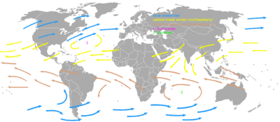
Prevailing winds
A region's prevailing and dominant winds are the result of global patterns of movement in the Earth's atmosphere.
Wind direction at any given time is influenced by synoptic-scale and mesoscale weather like pressure systems and fronts.
Sand dunes can orient themselves perpendicular to the prevailing wind direction in coastal and desert locations.
[5] The trade winds act as the steering flow for tropical cyclones that form over world's oceans, guiding their path westward.
[6] Trade winds also steer African dust westward across the Atlantic Ocean into the Caribbean Sea, as well as portions of southeast North America.
[8][9] These prevailing winds blow from the west to the east,[10] and steer extra-tropical cyclones in this general direction.
The westerlies can be particularly strong, especially in the southern hemisphere, where there is less land in the middle latitudes to cause the flow pattern to amplify, which slows the winds down.
[12] The westerlies play an important role in carrying the warm, equatorial waters and winds to the western coasts of continents,[13][14] especially in the southern hemisphere because of its vast oceanic expanse.
The westerlies explain why coastal Western North America tends to be wet, especially from Northern Washington to Alaska, during the winter.
This results in moisture-rich air flowing east from the Pacific Ocean, causing frequent rainstorms and wind on the coast.
This explains why most of coastal Western North America in the highest latitude experiences dry summers, despite vast rainfall in the winter.
At night, the land cools off more quickly than the ocean due to differences in their specific heat values, which forces the daytime sea breeze to dissipate.
If the slopes are covered with ice and snow, the mountain breeze will blow during the day, carrying the cold dense air into the warmer, barren valleys.
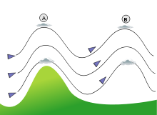
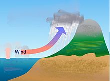
Moisture is removed by orographic lift, leaving drier air (see foehn wind) on the descending and generally warming, leeward side where a rain shadow is observed.
[24] In South America, the Andes mountain range blocks Pacific moisture that arrives in that continent, resulting in a desertlike climate just downwind across western Argentina.
[25] The Sierra Nevada range creates the same effect in North America forming the Great Basin and Mojave Deserts.
[28] As such, fine line patterns within weather radar imagery, associated with converging winds, are dominated by insect returns.