Wisconsin Avenue
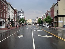
The southern terminus begins in Georgetown just north of the Potomac River, at an intersection with K Street under the elevated Whitehurst Freeway.
From the Georgetown riverfront on the Potomac River, Wisconsin Avenue climbs steeply north through Northwest Washington, D.C. along two travel lanes, with parked vehicles generally filling both curb lanes.
From the Tenleytown-AU station north, Wisconsin Avenue runs approximately parallel to the Red Line of the Washington Metro.
Early marched down this road from Monocacy Junction in an attempt to take Washington, D.C. that ended in the Battle of Fort Stevens.
[1][2] A route from M Street to a loop at Friendship Heights was still running when the District's streetcar system shut down in 1962.