Wisconsin Highway 131
The highway is located in Wisconsin's Driftless Area, passing through Crawford, Vernon, Richland, and Monroe counties.
It was realigned and extended several times in the next twenty-five years, and by 1948 it connected Wauzeka and Tomah roughly along its present route.
WIS 131 runs through hilly, rural terrain characteristic of the Driftless Area and Western Upland for its entire length.
Outside of Readstown, WIS 131 cuts east and passes through the community of Kickapoo Center before turning back north toward Viola.
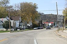
[4] The highway enters Viola from the southwest as Commercial Street, passes Kickapoo High School[5] and briefly becomes concurrent with WIS 56.
[7] WIS 131 passes through unincorporated Rockton and briefly enters the southwest corner of Wildcat Mountain State Park before reaching the village of Ontario.
As WIS 131 crossed the river eleven times between these towns, the state had to relocate the highway to make way for the dam.
[21][22][23] The original highway was abandoned at first, as the dam was expected to flood the surrounding area, but was later converted to a recreational trail.
[25] The relocation plans were put on hold when work halted on the dam project, which was ultimately canceled in the 1990s; the federal government did not fully resolve the ownership of the underlying land until 2000.
[24] Despite continued talks of reconstructing WIS 131 in the 1980s and 1990s, the ownership issues and local opposition delayed any plans to rebuild it.
In the meantime, the section between Rockton and Ontario received little to no maintenance, leaving the road with a heightened accident rate and issues with flooding.