Wisconsin River
It originates in the forests of the North Woods Lake District in Lac Vieux Desert on the border with the Upper Peninsula of Michigan.
North of Madison at Portage the river turns to the west,[6] flowing through Wisconsin's hilly Western Upland and joining the Mississippi approximately 3 miles (4.8 km) south of Prairie du Chien.
Before the Grandfather Falls dam was built in Lincoln County, that series of rapids constituted the largest drop in a short distance on the river.
[8] The river borders Adams, Juneau, Columbia, Sauk, Dane, Iowa, Richland, Grant, and Crawford Counties.
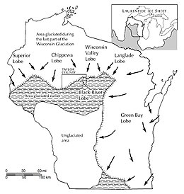
As the climate warmed and that ice sheet receded about 14,000 years ago, meltwater drained down the valley, eventually cutting a course similar to the modern river.
[6] The next segment, from Merrill to around Wisconsin Rapids, was probably formed as earlier glaciers retreated, hundreds of thousands of years ago.
Like the northern segment, the bedrock beneath is pre-Cambrian igneous and metamorphic rock - hard-to-erode stuff that produces frequent rapids.
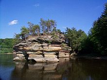
When warming began to melt back the ice against the Baraboo Hills, about 18,000 years ago, the flowing water quickly opened the gap and poured through, carving the Wisconsin Dells and cutting the start of the river's channel through the sand plain.
[6][11][12] Native Americans had long used the Wisconsin as a highway through the forests, canoeing and fishing it, living along its banks and burying their dead there.
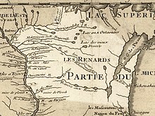
[14]: 16 In 1673, French missionary Jacques Marquette, French-Canadian explorer Louis Joliet, five voyageurs, and two Miami guides arrived near the headwaters of the Fox River - modern-day Portage.
It is very wide; it has a sandy bottom, which forms various shoals that rend its navigation very difficult.This is the first recorded mention of the name that evolved into "Wisconsin," which the state ended up taking.
Indians and early French residents offered meanings ranging from "stream of a thousand isles" to "gathering of waters" to "muskrat house."
A railroad executive observed wryly that "navigation could never be secured upon the Wisconsin river until its bottom had been fully lathed and plastered."
And railroads finally finished the canal scheme, criss-crossing much of the state by the 1860s and providing a means of hauling freight that ran in winter when the rivers were frozen and in summer when they were low.
[24] Far to the south on the savannas of southern Wisconsin and the treeless prairies of Iowa, Illinois and Missouri, settlers needed lumber to build their barns and houses.
In that era before trucks or even roads, the Wisconsin River offered a way to move lumber from the forests to markets downstream - an efficient way!
The logging companies built special splash dams to raise water levels when the natural spring floods weren't enough.
Six or seven of these cribs were connected into a long, narrow "rapids piece", which could flex at the joints as it went over a rapids or dam - a bit like a string of roller-coaster cars 16 feet wide and 100 feet long, with heavy bumper logs across the front and back, and "spring poles" along each side to tip the front crib up a bit.
)[4]: 155–162 When the ice was out and the river's water level was high enough, a fleet of twenty or forty of these 100-foot-long rafts would set out under the direction of a pilot.
Dams were built then with a slide for rafts - a gap about 50 feet wide leading to a ramp of logs descending to the water below.
A spectator described a raft going over a dam: The moment the bow entered the slide it was literally jerked down, and disappeared beneath the wild waters.
Mowe saved by their daring and skillful handling of a skiff the life of a poor fellow clinging to one of the new piers.
[30] These improvements were initially made by individual companies, along with splash dams and lumber booms, but it became clear that these investments affected everyone and the burden should be shared and coordinated.
[25]: 48-50 When the rafts reached Point Basse below Wisconsin Rapids, they entered a tamer sand-bottomed part of the river.
From this point, the pilot led a string of rafts slowly down the winding river, trying to avoid shifting sandbars.
The whole trip from central Wisconsin to St. Louis took from three weeks to all summer, depending on how much water was flowing and the skill of the raftsmen.
[32] The dams also spurred tourism, creating reservoirs such as Lake Wisconsin that are popular areas for recreational boating and fishing.
[33] Twenty-five hydroelectric power plants operate on the upper part of the river, above Prairie du Sac.
According to the Wisconsin Department of Natural Resources, two thirds of river users can be found on the stretch between Prairie du Sac and Spring Green.