Woronora
Woronora is located 27 kilometres south of the Sydney central business district, in the local government area of the Sutherland Shire.
A range of phonetically similar words are present in the sources: We may tentatively conclude therefore that *-ngurra could function as a locative suffix in Dharug.
Guesses regarding the original form of the placename depend largely upon the degree of mishearing assumed to have taken place between the Aboriginal informant and the European recorder.
Although English speakers frequently reproduced trilled rhotics as either /r/ or /l/ orthographically (Donaldson 2002:235[15]), it is difficult to establish whether the name was misheard from Aboriginal sources three times (producing the Wooloo-, Wolo-, and Woro- variants), or whether the change in spelling was a product of changing European pronunciation without reference to Aboriginal people.
The latter is quite likely considering that until the 1840s, and possibly beyond, it was the only official placename from the mouth of the river southwards (Dixon 1841[16]), and thus must have been written and pronounced frequently in reference to a large area.
Assuming therefore that the original placename most closely resembled Wooloonora, and acknowledging the inadequacy of our records due to language loss, three potential definitions present themselves: Cultural information could be the deciding factor in defining Woronora.
Governor Lachlan Macquarie named the nearby Georges River in 1810, and by the 1830s, European settlers began to move into the area, primarily for agriculture and timber resources.
However, the rugged terrain and the presence of the river made the area less accessible and less developed than some other parts of Sydney.
As Sydney expanded in the late 19th and early 20th centuries, Woronora began to see more development, though it remained relatively rural for a long time.
The dam was built to supply water to Sydney and had a considerable impact on the local environment, transforming parts of the region.
[citation needed] After World War II, Sydney's population boom prompted the development of suburbs like Woronora.
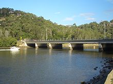
[1] The Woronora Bridge was built to eliminate the steep descents and ascents for traffic between Sutherland and Menai.
In 2006, Frank Sartor, a member for the NSW State Government intervened and zoned the fire trail such that it would not be able to be used for public or general transport.
Woronora features an RSL Club, boatshed, rugby league football oval (which is also a cricket ground in summer), caravan park, primary school which opened in 1942, cafe, restaurant (riverside), a fire station, hairdresser, bottle shop, general store and the Sutherland Region Guides Hall, situated by the Woronora River.
[20] On the west side of the Woronora River there is collection of streets which are named after Australian rural towns or waterways derived from Aboriginal language words.