Wouri estuary
The estuary lies in the Douala Basin, a low-lying depression about 30 metres (98 ft) on average about sea level, with many creeks, sand bars and lagoons.
[1] The Plio-Pleistocene Wouri alluvial aquifer, a multi-layer system with alternating sequences of marine sands and estuarine mud and silt lies below the estuary and surrounding region and is an important source of well water.
The upper aquifer in this system is an unconfined sandy horizon that is hydraulically connected to the brackish waters of the estuary and to the coastal wetlands.
[5] The Wouri is affected by the tides for 45 kilometres (28 mi) above Douala, with blocks of tidal forest along its shores throughout this stretch.
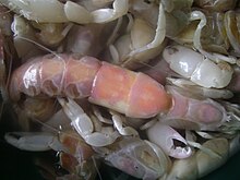
At these times, people catch huge quantities, eating the females or drying them for later use, and making a fish oil from the males.
[3] About 15,000 hectares (37,000 acres) of the mangrove forest is within the Mouanko Reserve, which extends from the south shore of the estuary to the Sanaga River mouth.
[11] Nypa fruticans, an exotic species imported to Nigeria from South-East Asia, has been spreading quickly, encouraged by the local people.
[12] The mangrove forests are an important source of wood for making furniture and fences, for smoking fish and for fuel.
[16] The people of the estuary became trading intermediaries, carrying European goods to the inland regions by canoe and bringing back ivory, slaves and palm products.
[19] By the 1830s, the slave trade was in terminal decline due to reduced demand from the United States and punitive action by the British based on the island of Fernando Po.
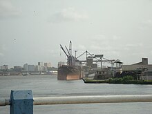
[26] The port of Douala is limited in its capacity due to its location on the river Wouri, which carries heavy loads of sediment and needs constant dredging.
The ecology of the estuary is under threat from growing pollution from industry, farming and households, threatening both fish yields and human health.
[30] The growing population is increasing production of export crops such as coffee, cocoa, bananas, palm oil and cotton, using imported pesticides and fertilizers.
[30] Douala's Bassa industrial zone ends in the estuarine creek formation of the Dibamba River, discharging pollutants.
The wetlands are quickly being colonized by invasive species, and a great number of phytoplankton have been identified, some of which are caused by the pollution.
As of 2002, the dense mangrove swamp forest, which included luxuriant growths of palms, was undergoing extinction due to urbanization.
[30] A 1991 study showed excessive levels of DDTs and PCBs in fish, shrimp and oysters in the area around Douala.
The Matanda block in the northern half of the estuary and the surrounding region has estimated reserves of between 60 and 300 million barrels.
Exploratory work by Gulf Oil several decades ago indicated that production of 4 million barrels a year could be feasible.
[33] In April 2008, a subsidiary of Swiss firm Glencore International AG and Afex Global Limited signed a deal with the Cameroon state oil company for a $38 million exploration project in the 1,187 square kilometres (458 sq mi) zone, which was approved by Badel Ndanga Ndinga, Minister of Industries, Mines and Technological Development.