Wungong, Western Australia
[3] The earliest documented use of the suburb's name is in J W Gregory's survey of Canning Location 22 dated April 1844[4] which maps the course of the 'Woongan River' for the first kilometre west of the hills and shows the land selected by G & J Armstrong which they developed into what became known as 'Wongong' farm.
[5] The name, Aboriginal in origin, is said to mean "embracing" in the Nyungar language and derives from the manner in which the north and south branches of Wungong Brook clasp the parcel of land that was the centre of the Armstrong's farm.
[10] Until around 1900, settlement in the district was more or less limited to Wongong farm, an adjoining property owned by Claude Marsh, Edward Gibbs's smallholding in the hills named 'Cooliabbera' and Walter Butcher's property at Upper Wongong (situated in wide section of the gorge where the Admiral Road reserve crosses).
In the 1890s, the sale of a vast tract of undeveloped land owned by Samuel Hamersley (also owner, for a time, of Wongong farm) and its subsequent subdivision by an Eastern States speculator named Goss opened up the area with a patchwork of small rural lots averaging some 60 acres (24 ha) apiece.
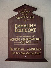
Names of other early families included Cockshott, Hilbert, Sermon, Marsh, Billingham, Whiteley, Cassell, Dutton, Smith, Aitkin, Mills, Baggs, Grafham, Henderson and Wheeler.
The most prominent of these settlers was Walter Butcher who built up a productive farm downstream from the present location of Wungong Dam.
Areas cleared for pasture land, introduced trees and some artifacts of Butcher's farm are still extant, as are remnants of a government-built timber bridge where the Admiral Road reservation - which passed through his farmyard - fords the river.
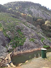
[13] It has a capacity of 60 million kilolitres and, when full, its storage area covers 30 hectares stretching 5.8 kilometres back from the dam wall.
The largest excavation was in the Wungong town reserve, but already by the 1920s this was filled with water and occasionally used by local youths as a swimming hole.
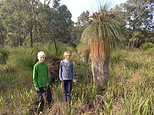
This reserve has the Cooliabbera Creek running along its north-eastern boundary and is characterized by open forest of marri (Corymbia calophylla) and dense shrubbery dominated by grass trees (Xanthorrhoea preissii and Kingia australis).
From 1980, the 10 acres (4.0 ha) area through which the creek flows has been leased to the Wallangara Riding and Pony Club which has developed an arena, bridle trails, jumps and clubroom facilities on the site.
In the earliest years of motor cars, the brook in the vicinity of the South Western Highway was well known a picnic destination.
The Wongong Gorge and the hills which form a backdrop to the district have been favoured by bushwalkers, including local residents.
A great deal of bushland has been preserved in the hills east of Wongong, a significant area of which is Bungendore Park.
The oldest of this suburban development is located immediately south of Gwynne Park (which for a long time defined the south-west limit of Armadale township), obliterating the old properties of 'Chinnor', 'Chiltern' and 'Trefoil Noir', as well as a few other smallholdings.