Wutach Gorge
The gorge cuts through the southern part of the Baar region from the eastern side of the High Black Forest heading eastwards to the Trauf the steep, northwestern flank of the Swabian Jura, which transitions to the Randen mountains here.
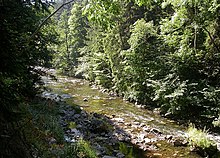
Their geologically young, prototypical and actively continuing development results in a great variety of geotopes and biotopes that support a correspondingly rich range of flora and fauna.
The Mesozoic rock layers were clearly inclined more steeply than usual here (on average 7%) by the uplifting of the southern Black Forest and have been cut through here in succession by the Wutach.
Because the Wutach "only" descends through a gradient of around 1% as it flows eastward, increasingly younger rocks are encountered, each overlaid over its predecessor, as one progresses down the gorge.
As these rocks each produce their own peculiar and very different landforms when they are cut by vertical erosion, one of the most diversified and most interesting gorge landscapes in Central Europe has resulted.
At the exit of the wide bottomed valleys of the Gutach and the Haslach from the eastern Black Forest, which were heavily shaped by the ice age, the streams often cut through narrow gorges as the gradient increases suddenly.
Shortly afterwards the stream passes the covered, wooden Stallegg Bridge, on the old path between the Fürstenberg estates on either side of the gorge.
The rocks lie north of the Wutach and are quartz porphyry formation up to 80 metres high that are also called the Nägelefels due to the presence of Cheddar Pinks.
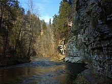
The limestones, which have been heavily deformed and made slippery by the leaching of gypsum deposits, have given rise to a slightly wider V-shaped valley with a great diversity of habitats and constantly changing local relief.
The centre of the valley was the historic Badhof near the Fritz Hockenjos Footbridge; an avenue and the remains of the park have survived.. On a rocky spur above it, New Tannegg Castle (built by about 1200) had to be abandoned before 1500, because it had partially collapsed down the precipitous cliff.
The Ludwig Neumann Way (Ludwig-Neumann-Weg) is one of the most elaborate trail systems maintained by the Black Forest Club and, after almost all the bridges in the original network were destroyed by floods, is exposed but protected by the rock faces.
The Forellenfelsen also recalls the early English fashion of travelling to the Black Forest for "fishing holidays" in the Wutach Gorge.
The almost undeveloped valley sides with their rugged, sometimes bizarre relief, leave one to conjecture at the almost continual slip and creep processes of the few remaining solid formations of Keuper rock.
Roughly in the middle of the gorge it is joined near the old mill of Bergmühle by the rather straight, rugged ravine known as the Engeschlucht through which the Tränkebach stream runs.
After the valley broadens out below the Gauchach Viaduct (which carries the Bundesstraße 31) the first narrow section begins near the restored and functional mill of Guggenmühle.
The actual gorge begins near the castle ruins of the Grünburg (wall remains measuring 15 x 12 m) and the Lochmühle mill, which was destroyed in a flood.
Below the ruins of the Neuenburg, which is barely recognisable following a landslip, the Burgmühle Hiking Hostel run by the Friends of Nature acts as a tourist base.