Yavapai County, Arizona
[2] Yavapai County comprises the Prescott Valley-Prescott, AZ Metropolitan Statistical Area as well as the northern portions of Peoria and Wickenburg, the balance of which are in the Phoenix Metropolitan Area.
The county territory was defined as being east of longitude 113° 20' and north of the Gila River.
The county is named after the Yavapai people, who were the principal inhabitants at the time the United States annexed the area.
It is larger than three U.S. states (Rhode Island, Delaware and Connecticut) and the District of Columbia combined.
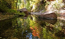
The county's topography makes a dramatic transition from the lower Sonoran Desert to the south to the heights of the Coconino Plateau to the north, and the Mogollon Rim to the east.
The highest point above sea level (MSL) in Yavapai County is Mount Union at an elevation of 7,979 ft (2,432 m) and the lowest is Agua Fria River drainage, now under Lake Pleasant.
[6] Yavapai County is also the location of several groves of the near-threatened California Fan Palm, Washingtonia filifera.
[7] Yavapai County is home to Arcosanti, a prototype arcology, developed by Paolo Soleri, and under construction since 1970.
Approximately 10 miles (16 km) northwest of the town of Bagdad lies the Upper Burro Creek Wilderness Area, a 27,440-acre (11,105 ha) protected area home to at least 150 species of birds and featuring one of the Arizona desert's few undammed perennial streams.
Yavapai County is defined as the Prescott Metropolitan Statistical Area by the United States Census Bureau.
[21] Yavapai has historically been the most Republican county in Arizona, though it has become rivalled by Graham and exceeded by Mohave since the turn of the century.