Yazoo Pass expedition
The Yazoo Pass expedition was a joint operation of Major General Ulysses S. Grant's Army of the Tennessee and Rear Admiral David D. Porter's Mississippi River Squadron in the Vicksburg campaign of the American Civil War.
Grant's objective was to get his troops into a flanking position against the Rebel defenders of the heavily armed Confederate citadel Vicksburg, Mississippi.
From the start, the expedition was delayed by natural obstacles that were more serious than the perfunctory Confederate resistance, so forward motion was as little as ten miles (16 km) a day.
Because progress was so slow, the Confederate Army under Lieutenant General John C. Pemberton was able to set up a fort and block passage of the Federal fleet near the town of Greenwood, Mississippi.
The Vicksburg campaign was bogged down in early 1863, following the repulse of the Union forces under Brigadier General William T. Sherman at Walnut Hills (or Chickasaw Bayou) late the previous year.
At the same time, he could divert a part of the expedition up the Yalobusha River to destroy a railroad bridge that was enabling the enemy to threaten his own line of communications.
[4] A preliminary survey by Acting Master George W. Brown in the tinclad USS Forest Rose confirmed the feasibility of the operation, and on February 3, 1863 a group of some 400 pioneers under Lieutenant Colonel James H. Wilson dug two gaps in the levee at the site where the Old Yazoo Pass had formerly met the Mississippi.
Five of the gunboats were of a type known colloquially as "tinclads," vessels of light draft carrying thin armor capable of protection only against infantry weapons: USS Rattler, Marmora, Signal, Romeo, and Forest Rose.
The other two were the larger and heavier Baron De Kalb, one of the original City class ironclads, and Chillicothe, an inferior second-generation copy.
An additional 600 or so soldiers were sent aboard the tinclads to defend them, if necessary, from Rebel boarding parties that could be expected in an operation so deep in enemy territory.
He immediately organized some work details to block the Yazoo Pass and Coldwater River by felling trees across the streams, but they were largely ineffective.
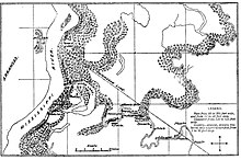
More serious, however, was a fort that Loring ordered to be built a few miles upstream from the point where the Tallahatchie and Yalobusha Rivers combine to form the Yazoo.
A peculiarity of the courses of the Tallahatchie and the Yazoo is that they flow past each other on opposite sides of a neck of land that is only a couple of hundred yards (or meters) wide.
[8] Here, Loring's men made a barricade of cotton bales, covered them with layers of dirt, and mounted a pair of heavy guns.
In addition, he had built a boom or raft that could be swung out to block the stream, and in the channel just downstream of this he scuttled a ship, the former Star of the West.
Instead of pushing ahead with his ironclads, Lieutenant Commander Smith insisted that the entire force, gunboats and transports alike, should move together.
Smith's torpor may have been a result of his declining health; he had been sick when the expedition started, but he had stayed on, hoping that he would improve when his fleet was in motion.
[11] The Union flotilla finally arrived in the vicinity of Fort Pemberton on March 11, more than five weeks after the levee at Yazoo Cut had been breached.
Baron De Kalb did not suffer any significant damage, because of her superior construction and because the Confederate gun crews concentrated their fire on the more vulnerable Chillicothe.
[13] The next day (March 12) was given over to repairing the damage suffered by the gunboats, and giving them additional protection by placing cotton bales on the foredecks.
Although she lost only three wounded among her crew, the pounding she took from the enemy artillery loosened many of her armor plates and generally revealed the inadequacy of her construction.
They had not gone far when they encountered a group of Union transports bringing in reinforcements under the command of Brigadier General Isaac F. Quinby, whose appointment predated that of Ross and who therefore ranked him.