Yellow River
[5] The area receives very uneven rainfall, only 2 percent of China's water runoff[5]—water and sediment flow has decreased five-fold since the 1970s, and until recently, the river frequently did not reach the sea.
These changes could cause the river's mouth to shift as much as 480 km (300 mi), sometimes reaching the ocean to the north of the Shandong Peninsula and sometimes to the south.
[28] Another historical source of devastating floods is the collapse of upstream ice dams in Inner Mongolia with an accompanying sudden release of vast quantities of impounded water.
Before modern disaster management, when floods occurred, some of the population might initially die from drowning and many more would suffer later from the ensuing famine and spread of diseases.
[31] Historical documents from the Spring and Autumn period[32] and Qin dynasty[33] indicate that the Yellow River at that time flowed considerably north of its present course.
[2] From around the beginning of the 3rd century, the importance of the Hangu Pass was reduced, with the major fortifications and military bases moved upriver to Tongguan.
In AD 923, the desperate Later Liang general Duan Ning again broke the dikes, flooding 1,000 square miles (2,600 km2) in a failed attempt to protect his realm's capital from the Later Tang.
[2] In 1128, Song troops under the Kaifeng governor Du Chong (杜充, Dù Chōng, d. 1141) breached the southern dikes of the Yellow River in an effort to stop the advancing Jin army.
[40] The 1642 flood was man-made, caused by the attempt of the Ming governor of Kaifeng to use the river to destroy the peasant rebels under Li Zicheng who had been besieging the city for the past six months.
The question of how aggressively flooding should be controlled, and whether it should be steered back to its original channels when it migrated, was a topic of controversy in the imperial court.
[44] Traditional flood control techniques made use of levees, revetments to absorb the energy of the water, overflow basins, drainage canals and polders.
[47] The difficult situation around the confluence of the Yellow River, the Huai, and the Grand Canal, however, still led to a major flood of the regional center Sizhou and Pan's dismissal from court.
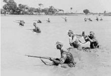
On 9 June 1938, during the Second Sino-Japanese War, Nationalist troops under Chiang Kai-shek broke the levees holding back the river near the village of Huayuankou in Henan, causing what has been called by Canadian historian, Diana Lary, a "war-induced natural disaster".
According to the China Exploration and Research Society,[52] the source of the Yellow River is at 34°29′31″N 96°20′25″E / 34.49194°N 96.34028°E / 34.49194; 96.34028 in the Bayan Har Mountains near the eastern edge of the Yushu Tibetan Autonomous Prefecture.
In the Zoige Basin along the boundary with Gansu, the Yellow River loops northwest and then northeast before turning south, creating the "Ordos Loop", and then flows generally eastward across the North China Plain to the Gulf of Bohai, draining a basin of 752,443 square kilometers (290,520 sq mi) which nourishes 140 million people with drinking water and irrigation.
[53] The Yellow River passes through seven present-day provinces and two autonomous regions, namely (from west to east) Qinghai, Sichuan, Gansu, Ningxia, Inner Mongolia, Shaanxi, Shanxi, Henan, and Shandong.
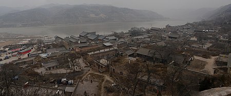
Major cities along the present course of the Yellow River include (from west to east) Lanzhou, Yinchuan, Wuhai, Baotou, Luoyang, Zhengzhou, Kaifeng, and Jinan.
[56] The upper reaches of the Yellow River constitute a segment starting from its source in the Bayan Har Mountains and ending at Hekou Town (Togtoh County), Inner Mongolia just before it turns sharply to the south.
Flowing east at the eastern edge of the Amne Machin Mountains, the Yellow River enters Maqu County in Gansu.
Flowing now along the northern edge of Amne Machin, the river reenters Qinghai and gradually curves north towards the Longyang Gorge at Xinghai.
The Ordos Loop formed by an enormous twist of the Yellow River, beginning at Zhongning County in Ningxia and ending with a drastic eastward turn at its confluence with the Wei at Tongguan in Shaanxi.
In the lower reaches, from Zhengzhou to its mouth, a distance of 786 km (488 mi), the river is confined to a levee-lined course as it flows to the northeast across the North China Plain before emptying into the Bohai Sea.
[51]: 168 The Yellow River is notable for the large amount of silt it carries—1.6 billion tons annually at the point where it descends from the Loess Plateau.
In order to capture excess water for use when needed and for flood control and electricity generation, several dams have been built, but their expected life is limited due to the high silt load.
[61][54] However, due to habitat loss, pollution, introduced species and overfishing many of the natives have declined or disappeared entirely; several are recognized as threatened on China's Red List.
For example, the uppermost, highest parts on the Qinghai–Tibet Plateau has relatively few native species, notably snowtrout and allies (Gymnocypris, Gymnodiptychus, Platypharodon and Schizopygopsis), and Triplophysa loaches.
[61][54][64] Other species that support important fisheries include white Amur bream, ayu, mandarin fish, Protosalanx icefish, northern snakehead, Asian swamp eel and others.
It is farmed in large numbers in several parts of China and genetic studies have revealed that the captive stock mostly is of Yellow River origin.
The Chinese idiom "when the Yellow River flows clear" is used to refer to an event that will never happen and is similar to the English expression "when pigs fly".
[citation needed] "The Yellow River running clear" was reported as a good omen during the reign of the Yongle Emperor, along with the appearance of such auspicious legendary beasts as qilin (an African giraffe brought to China by a Bengal embassy aboard Zheng He's ships in 1414) and zouyu (not positively identified) and other strange natural phenomena.