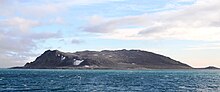
Ytre Norskøya
Remains of a whaling station exist on the southern side of the island, possibly rivaling Smeerenburg in size.
To the west of these structures were buildings used by the men working ashore.
The station probably belonged to the Zeeland partners of the Noordsche Compagnie, who were forced to settle on Ytre Norskøya sometime after 1619 because the whaling vessels belonging to Amsterdam would not allow them to establish themselves at Smeerenburg.
A high look-out point on the island called Zeeusche Uytkyk (Zeeland Look-out) was used by the Dutch to search for the spouts of bowhead whales.
The name appears on Henrik Doncker's 1655 map of Mauritius Bay (modern Smeerenburgfjorden), which, however, shows the bay as it was in the 1620s (when the Danes abandoned Smeerenburg).