Yunfu
It borders Zhaoqing to the north, Foshan to the east, Jiangmen to the southeast, Yangjiang to the south, Maoming to the southwest, and the autonomous region of Guangxi to the west.
[3] Shortly after the creation of the Republic of China in 1912, republican officials reorganized the area multiple times.
[6] The largest ethnic minorities in Yunfu are the Zhuang, Yao, Dong, and the Miao.
[6] While many of Yunfu's ethnic minorities recently moved to the city due to marriage and work, there are large concentrations of indigenous minorities in two villages in Yunfu: Hejiang Village (Chinese: 合江村) in Jiayi [zh], Luoding, and Dalin Village (Chinese: 大林村) in Baozhu [zh], Yunan County.
[citation needed] More than 670 types of plants used in traditional Chinese medicine are found in Yunfu.
[2] Other proven minerals in Yunfu include tin, lead, zinc and manganese, sillimanite, dolomite, barite, talc, kaolin, limestone, clay, rammell, potassium feldspar, and mineral water.
[citation needed] The area's particularly large deposits of pyrite makes it China's largest sulfide producing region.
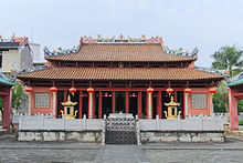
[2] The city has 6 art galleries and cultural centers, 6 public libraries, and 5 museums.
[2] With 324 National Highway running through the whole prefecture, cement-paved roads are accessible to each single township and village.
[citation needed] The Xi River has 100 kilometers of waterway, enabling direct cargo freight to Hong Kong.