Zermatt
It has a year-round population of about 5,800 and is classified as a town by the Swiss Federal Statistical Office (FSO).
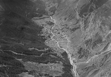
It lies at the upper end of Mattertal at an elevation of 1,620 m (5,310 ft), at the foot of Switzerland's highest peaks.
Until the mid-19th century, it was predominantly an agricultural community; the first and tragic ascent of the Matterhorn in 1865 was followed by a rush on the mountains surrounding the village, leading to the construction of many tourist facilities.
[6] The name of Zermatt, as well as that of the Matterhorn itself, derives from the alpine meadows, or matten (in German), in the valley.
The reason of this change from Praborno to Zermatt is attributed to the gradual replacement of the Romance-speaking people by German-speaking colony.
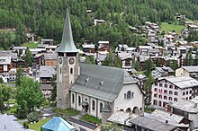
There are three main streets which run along the banks of the Matter Vispa, and numerous cross-streets, especially around the station and the church which forms the centre of Zermatt.
The Matterhorn was one of the last alpine mountains to be summitted (in 1865), and the first expedition that reached the top ended dramatically with only 3 of the 7 climbers surviving the descent.
Zermatt is a starting point for hikes into the mountains, including the Haute Route that leads to Chamonix in France and the Patrouille des Glaciers.
Zermatt is also the western terminus for the Glacier Express rail service connecting to St. Moritz and the MGB (Matterhorn Gotthard Bahn).
Passenger vehicles operating within Zermatt include small electric shuttles provided by hotels to carry visitors from the main train station (or the taxi transfer point just outside town) to the hotel properties, "electro" taxis operated by four major Zermatt families, and "electro" buses, which serve two routes: one between the major hotel areas and the stations of the various ski-lifts, and the other following a similar route but also serving the more rural "suburb" of Winkelmatten.
Trains also depart for Zermatt from farther down the valley at Visp and Brig, which are on the main Swiss rail network.
The town also has a heliport (ICAO: LSEZ) and a local helicopter operator, Air Zermatt, which also provides alpine rescue services.
In 2007, a project group was formed to evaluate options for development of the local transportation network (as the "electro" buses do not have enough capacity).
The six options explored are a coaster, a funicular, a metro, moving sidewalks, a gondola and more "electro" buses.
[16] In 2019 work started to improve access on the Kirchbrücke – one of the most popular places to photograph the Matterhorn.
[21] The Sunnegga Paradise is accessed via the SunneggaExpress funicular railway, followed by a gondola to Blauherd and finally a cable car onwards to the Rothorn (3,103 m) above.
The topography of the mountain and the valley tends to keep the Rothorn clear and sunny, even when Zermatt is submerged in cloud.
This cable car and the newer 4-seat chairlift Sunnegga-Findeln-Breitboden provide connections between Sunnegga and Gornergrat.
This final lift serves a freeride area but can be unreliable as this mountainside requires good snow cover to be skiable.
Near the southern end of Zermatt, the Matterhorn Express gondola transports passengers up to the interchange station at Furi.
Testa Grigia at the top of the Theodul Pass serves as a connection to the Italian ski-resorts of Cervinia and Valtournenche.
In March 2019 it was announced that a new lift – the 'Alpine Crossing' – will connect Testa Grigia and Klein Matterhorn from spring 2021.
In operation since 25 October 2003, the Furggsattel six-seater chairlift has twelve (of eighteen) masts that stand directly on the glacial ice of the Theodul Glacier – a first for Switzerland.
The new CHF52 million 3S Glacier Ride Cable Car from the resort to Klein Matterhorn was opened on 29 September 2018.
It has an uplift capacity of 2000 people per hour and takes just 9 minutes to reach the top using 25 cabins, each with 28 seats.
[24] The Zermatt Bergbahnen's website[26] mentions a few projects for the following years: As well as several changes to the slopes, and the placement of new snowmaking installations.
The blazon of the municipal coat of arms is Gules a lion rampant Or langued of the first on a trimount Vert between two mullets of five Argent in chief.
[12] The historical population is given in the following chart:[33] The petroglyphs and prehistoric grinding stone at Hubelwäng is listed as a Swiss heritage site of national significance.
In the tertiary sector, 531 or 14.3% were in wholesale or retail sales or the repair of motor vehicles, 477 or 12.9% were in the movement and storage of goods, 2,178 or 58.8% were in a hotel or restaurant, 38 or 1.0% were in the information industry, 54 or 1.5% were the insurance or financial industry, 116 or 3.1% were technical professionals or scientists, 56 or 1.5% were in education and 87 or 2.3% were in health care.
The education system in the Canton of Valais allows young children to attend one year of non-obligatory Kindergarten.