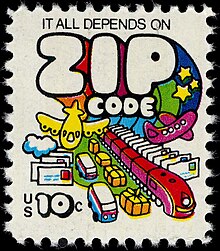
ZIP Code
The United States Post Office Department (USPOD) implemented postal zones for 178 large cities in May 1943.
[9] For example: Mr. John Smith 3256 Epiphenomenal Avenue Minneapolis 16, Minnesota The "16" is the number of the postal zone in a specific city.
[10] By the early 1960s, a more organized system was needed, and non-mandatory five-digit ZIP Codes were introduced nationwide on July 1, 1963.
[11] According to Publication 59, the two-letter standard was "based on a maximum 23-position line, because this has been found to be the most universally acceptable line capacity basis for major addressing systems",[11] which would be exceeded by a long city name combined with a multi-letter state abbreviation, such as "Sacramento, Calif." along with the ZIP Code.
The abbreviations have remained unchanged, with the exception of Nebraska, which was changed from NB to NE in 1969 at the request of the Canada Post Corporation, to avoid confusion with New Brunswick.
[11] Robert Moon is considered the father of the ZIP Code; he submitted his proposal in 1944 while working as a postal inspector.
[12][13] The phrase "zone improvement plan" is credited to D. Jamison Cain, a Postal Service executive.
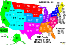
The mail is sorted according to the final two digits of the ZIP Code and sent to the corresponding post offices in the early morning.
In the case of large cities, the last two digits as assigned generally coincided with the older postal zone number.
[10] For example: Mr. John Smith 3256 Epiphenomenal Avenue Minneapolis, MN 55416 In 1967, these became mandatory for second- and third-class bulk mailers, and the system was soon adopted generally.
A ZIP+4 Code uses the basic five-digit code plus four additional digits to identify a geographic segment within the five-digit delivery area, such as a city block, a group of apartments, an individual high-volume receiver of mail, a post office box, or any other unit that could use an extra identifier to aid in efficient mail sorting and delivery.
[19] The ZIP Code is often translated into an Intelligent Mail barcode that is printed on the mailpiece to make it easier for automated machines to sort.
A barcode can be printed by the sender (some word-processing programs such as WordPerfect[20] include the feature), but this is not recommended, as the address-to-ZIP lookup tables can be significantly out of date.
The USPS publishes the rules for calculating the delivery point in a document called the CASS Technical Guide.
Government examples include 20505 for the Central Intelligence Agency in Washington, D.C., and 81009 for the Federal Citizen Information Center of the U.S. General Services Administration (GSA)[22] in Pueblo, Colorado.
In the '0' region are New Jersey (non-contiguous with the remainder of the '0' area), Puerto Rico, the U.S. Virgin Islands, and APO/FPO military addresses for personnel stationed in Europe, Africa, Southwest Asia, and onboard vessels based in the waters adjoining those lands.
Until 2001, there were six ZIP Codes lower than 00501 that were numbered from 00210 to 00215 (located in Portsmouth, New Hampshire) and were used by the Diversity Immigrant Visa program to receive applications from non-U.S.
For example, 40202 is in Louisville, 50309 in Des Moines, 60601 in Chicago, 63101 in St. Louis, 77036 in Houston, 80202 in Denver, 94111 in San Francisco, 98101 in Seattle, and 99950 in Ketchikan, Alaska (the highest ZIP Code).
[citation needed] For example, the U.S. Embassy in India has this address in India's postal system:[28] Embassy of the United States of America Shantipath, Chanakyapuri, New Delhi, National Capital Territory of Delhi, 110021 as well as this U.S. address:[29] Embassy of the United States of America 9000 New Delhi Place Washington, DC 20521-9000 Individuals posted at diplomatic missions overseas are now assigned a Diplomatic Post Office address and unique box number.
[37] Due to convenience, ZIP Codes are used not only for tracking of mail, but also commonly for gathering geographical statistics in the United States by some researchers.
[39][40] As ZIP Codes are not polygons, but collections of mail routes and points, they are unsuitable for publication or distribution of most data.
[38] Demographic data is not consistent between ZIP Codes, and no effort is made to ensure they are proper enumeration units for analysis.
[38] The resulting aereal units represent the approximate extent of the ZIP Code which are combined with to use for mapping and data presentation.
Despite these issues, ZCTAs are still very popular with researchers in fields like epidemiology, and among government agencies, with some states employing them to publish and distribute public health data during the COVID-19 pandemic.
Besides providing purchasing-pattern data useful in determining the location of new business establishments, retailers can use directories to correlate this ZIP Code with the name on a credit card to obtain a consumer's full address and telephone number.
ZIP-Coded data are also used in analyzing geographic factors in risk, an insurance and banking industry practice pejoratively known as redlining.
[45] One proposal to eliminate the possibility of extreme partisan gerrymandering calls on using ZIP Codes as the basic units for redistricting.
Postal network, websites that require ZIP Codes cannot register customers outside the United States.
Examples (in addition to the store locator example listed above) include weather forecasts, television listings, local news, and online dating (most general-purpose sites, by default, search within a specified radius of a given ZIP Code, based on other users' entered ZIP Codes).
In some cases, the ZIP Code is the only thing used for AVS, specifically where collecting a signature, or other information is infeasible, such as pay at the pump or vending machines.