South Holland
Archaeological discoveries in Hardinxveld-Giessendam indicate that the area of South Holland has been inhabited since at least c. 7,500 years before present, probably by nomadic hunter-gatherers.
After the departure of the Romans, the area belonged to the Frisian Kingdom, after which it was conquered by the Frankish king Dagobert I in 636.
In 690, the Anglo-Saxon monk Willibrord arrived near Katwijk and was granted permission to spread Roman Catholicism by the Frankish king Pepin II.
The city retained a dominant position in the area until it was struck by a series of floods in the late 14th century.
Both his daughter Jacqueline and his brother John, the latter supported by Philip the Good, Duke of Burgundy, claimed the throne.
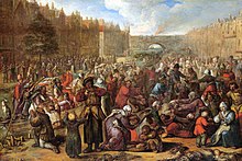
During the Eighty Years' War, the area of South Holland was the scene of the Capture of Brielle, the Siege of Leiden and the assassination of William the Silent.
The United Netherlands declared their independence in 1581, and Holland quickly emerged as the country's dominant province, with important trading cities such as Leiden, Delft, Gouda and Dordrecht.
The south of Holland, back then often referred to as the Zuiderkwartier (literally "South Quarter"), was the birthplace and residence of scientists such as Antoni van Leeuwenhoek and Christiaan Huygens, philosophers such as Baruch Spinoza and Pierre Bayle, and painters such as Johannes Vermeer, Rembrandt van Rijn and Jan Steen.
The islands in the south were merged with Zeeland and the west of North Brabant to form the Department of the Scheldt and Meuse.
Even though the province had been reunited, the two areas were still treated differently in some ways and the idea of dividing Holland remained alive.
In the late 20th and early 21st centuries, five municipalities were transferred from South Holland to Utrecht; Oudewater in 1970, Woerden in 1989, Vianen in 2002, Leerdam and Zederik in 2019.
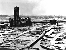
The subsequent German occupation of the Netherlands resulted in anti-Jewish measures, and many members of Dutch resistance were captured and executed on the Waalsdorpervlakte.
The centre of South Holland and the area along the coast in the west are largely urban, part of the Randstad conurbation, while the east of the province is more agrarian and belongs to the Groene Hart, literally Green Heart.
The Duin- en Bollenstreek is a region in the northwest of South Holland, around Katwijk, that features coastal dunes and the cultivation of flower bulbs.
The easternmost tip of South Holland is part of De Biesbosch, one of the largest national parks of the Netherlands and one of the last freshwater tide areas in Europe.
[7] The Kagerplassen are a collection of lakes north-east of Leiden, popular for boating, watersports, fishing, camping and walking.
Other regions in South Holland include Alblasserwaard, Gouwestreek ("The Gouwe Area"), Hoeksche Waard, Krimpenerwaard, Rijnland ("Rhineland"), Rijnstreek ("The Rhine Area"), Vijfheerenlanden and Westland (roughly including Hook of Holland and the municipalities of Westland and Midden-Delfland).
The climate is influenced by the North Sea and the Atlantic Ocean, which results in relatively cooler summers and milder winters.
Eastern winds can result in temporary continental climate conditions with relatively warm and dry summers and cold and stormy winters.