14 regions of Medieval Rome
But as Rome slowly recovered from the disasters of the Gothic wars it became necessary to organize the city for the purpose of defence, and one theory contends that this was the origin of the twelve medieval regions.
[1] In particular, it is suggested that it was connected with the Byzantine military system (the scholae militiae) and was introduced into Rome in the 7th century, along with its implementation at Ravenna.
It has been conjectured[2] that the sack of Rome by Robert Guiscard in 1084 caused a displacement of the population which probably made a revision of the regions necessary.
The district from the Lateran Palace to the Colosseum was engulfed and ruined by fire, and the Caelian and Aventine hills were gradually abandoned.
At that time it included all the Aventine Hill and it stretched across the Marmorata and the Ripa Graeca, butting up against the banks of the Tiber River.
It incorporated the areas around Santi Quattro Coronati, the Aqua Claudia (between the Caelian and Palatine hills), the Circus Maximus, the Septizodium and the Porta Metronia.
• The fifth region contained the part of the Campus Martius which housed the Mausoleum of Augustus, the Column of Marcus Aurelius, the Via Lata and the church of San Silvestro in Capite.
• The ninth region was given the label ad Scorticlarios, named after the tanners quarter which was situated next to the Baths of Nero.
Apart from the Baths, this region also contained the church of Sant'Eustachio, Piazza Navona, the Pantheon and San Lorenzo in Lucina.
The Colosseum had at some point during the Middle Ages been fortified and for a time belonged to the area controlled by the Frangipani family.
By its remaining active it enabled the region to survive well throughout the Middle Ages, although the change of its sources caused the water's properties (purity, taste, etc.)
A prominent feature during the Middle Ages was the Mons Acceptorius, a small artificial embankment created by the pre-Roman inhabitants in order to drive stilts into the swampy ground, and build dry huts for housing.
This bridge was built by Emperor Hadrian (and originally named after him Pons Aelius) in 134 to connect his mausoleum to the rest of the city.
In ancient Rome, the area belonged to the IX Augustan region called Circus Flaminius, that was a part of the Campus Martius.
The region was not widely inhabited due to the frequent flooding of the river Tiber, causing the whole area to be extremely unhealthy, especially during summer.
Under Sixtus IV (1471–1484) the rione lost much of its chaotic look, typical of the Middle Ages, for a cleaner and tidier one, in keeping with the changes brought about by the Renaissance.
It saw the recovery of buildings, the enlargement of streets, and the rebuilding of the ancient Pons Aurelius into a new bridge, the "Ponte Sisto" connecting Trastevere and Parione.
In 1500, most of the commercial activity slowly moved from Campo de' Fiori to Piazza Navona, due to the fact that it had more space for trading.
From at least the 16th century, and possibly much earlier, this region has been centered on the Basilica of San Marco, Santa Maria sopra Minerva and the Pantheon.
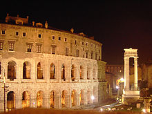
Referred to as Regione Marcello in the tenth century, by the 12th century, its name had changed to indicate that it included parts of the city around the fish market, which had moved from the Forum Piscarium, located near the Forum Romanum, into the ruins of the Porticus Octaviae, though it still included the Theatre of Marcellus, which now housed the shops of smiths and coppersmiths inside the arcades of the theater.
During the period of the high empire, a number of rich mansions stood here but they were mostly destroyed during the barbarian invasions of the 5th century, resulting in the area being almost completely abandoned, with the exception of a few convents on the heights of the Aventine Hill, located on a safer spot.
During the 10th century, this region was referred to as the Clivus Argentarii, and it contained the streets that now connect the Corso with the Forum Romanum (the old Via di Marforio).