1811–1812 New Madrid earthquakes
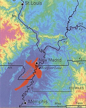
[10][11][12] The earthquakes, as well as the seismic zone of their occurrence, were named for the Mississippi River town of New Madrid, then part of the Louisiana Territory and now within the U.S. state of Missouri.
The epicenters of the earthquakes were located in an area that at the time was at the distant western edge of the American frontier, only sparsely settled by European settlers.
By the time we could get to our fire, which was on a large flag in the stern of the boat, the shock had ceased; but immediately the perpendicular banks, both above and below us, began to fall into the river in such vast masses, as nearly to sink our boat by the swell they occasioned ... At day-light we had counted twenty-seven shocks.Eliza Bryan[20] in New Madrid, Territory of Missouri, wrote the following eyewitness account in March 1812: On the 16th of December 1811, about two o'clock, a.m., we were visited by a violent shock of an earthquake, accompanied by a very awful noise resembling loud but distant thunder, but more hoarse and vibrating, which was followed in a few minutes by the complete saturation of the atmosphere, with sulphurious vapor, causing total darkness.
The screams of the affrighted inhabitants running to and fro, not knowing where to go, or what to do—the cries of the fowls and beasts of every species—the cracking of trees falling, and the roaring of the Mississippi— the current of which was retrograde for a few minutes, owing as is supposed, to an irruption in its bed— formed a scene truly horrible.John Reynolds, the fourth governor of Illinois, among other political posts, mentions the earthquake in his biography My Own Times: Embracing Also the History of My Life (1855):[21] On the night of the 15th of December 1811, an earthquake occurred, that produced great consternation amongst the people.
The New Madrid seismic zone is made up of reactivated faults that formed when what is now North America began to split or rift apart during the breakup of the supercontinent Rodinia in the Neoproterozoic era (about 750 million years ago).
[24] In a report filed in November 2008, the U.S. Federal Emergency Management Agency warns that a serious earthquake in the New Madrid Seismic Zone could inflict "the highest economic losses due to a natural disaster in the United States", further predicting "widespread and catastrophic" damage across Alabama, Arkansas, Illinois, Indiana, Kentucky, Mississippi, Missouri, and particularly Tennessee, where a 7.7 or greater magnitude quake would cause damage to tens of thousands of structures affecting water distribution, transportation systems, and other vital infrastructure.
Lake St. Francis in eastern Arkansas was expanded by subsidence, with sand and coal being ejected from fissures in the adjacent swamps as water levels rose by 8 to 9 meters.
The continuous underlying rock mass, uninterrupted by fractures or faults, conducted the seismic waves from the earthquakes over great distances, with perceptible ground shaking as far away as Canada.
[26][27] The earthquakes strengthened the Shawnee prophet Tenskwatawa after the defeat at the Battle of Tippecanoe and the destruction of Prophetstown, with local Native Americans seeing it as a vindication of his teachings and of the warnings of his brother Tecumseh.