1952 Kern County earthquake
The 1952 Kern County earthquake occurred on July 21 in the southern San Joaquin Valley and measured 7.3 on the moment magnitude scale.
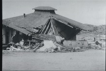
The main shock occurred at 4:52 am Pacific Daylight Time (11:52 UTC), killed 12 people, injured hundreds more and caused an estimated $60 million in property damage.
Following the event, a field survey was conducted along the fault zone with the goal of estimating the peak ground acceleration of the shock based on visually evaluating precarious rock formations and other indicators.
Ground disturbances that were created by the earthquakes were also surveyed, both in the valley and in the foothills, with both vertical and horizontal displacements present in the epicentral area.
Repercussions of the sequence of earthquakes were still being felt in the heavily damaged downtown area of Bakersfield well into the 1990s as city leaders attempted to improve safety of the surviving unreinforced masonry buildings.
The San Andreas has been responsible for considerable seismic activity at its northern and southern sections, and traverses the area near the Transverse Ranges.
The Owens Valley Fault, on the east side of the Sierran block, has been mapped and may possibly extend into area that was affected by the 1952 shocks.
The White Wolf Fault (as illuminated by the aftershocks) was found to be curved, with less dip on the northeast end, though that zone also had a higher strike-slip component.
The 1995 Working Group on California Earthquake Probabilities gave a (high uncertainty) slip rate estimate of 2 mm per year.
In Bakersfield, windows were broken and dislodged plaster littered residential and commercial districts, and the county jail was damaged.
In the small town of Taft disruption was light, with the exception of a destroyed wall at a J. C. Penney department store and a single home that was damaged.
In the (former) settlement of Paloma a fire burned at an oil refinery, and an explosion occurred at a refinery in Long Beach due to a cracked pipe, but most of the Greater Los Angeles Area was free from heavy damage due to the distant location (around 100 miles southwest of Tehachapi) of the earthquake.
Foam rubber modelling studies confirm that the ground motion on the foot wall side can be lower by a factor of up to five, and an example of this imbalance was displayed during the September 1999 M7.6 earthquake in Taiwan.
Northeast trending cracks ranging from hairline-width to near five inches wide were seen between Arvin and California State Route 166, and some showed clear lateral offset, but those were determined to be localized effects.
Charles Richter departed the lab in Pasadena in a mobile seismograph truck bound for the epicentral area to record aftershocks close to the fault, and Harry O.
[16] The American Red Cross called it a major disaster, but getting relief into the area was stalled because of landslides blocking the ridge route running between Los Angeles and Kern counties.
California State Route 99 was also blocked by a landslide ten miles south of Gorman, but the highway was quickly reopened later in the day.
All 417 inmates from the Tehachapi Prison for Women were evacuated because of damage; the California Department of Corrections stated that the facility was left unusable.
The Kern County Courthouse, St. Francis Church, and the original Beale Memorial Clock Tower were all damaged and were leveled or rebuilt.