1968 Illinois earthquake
[5] Although no fatalities occurred, the event caused considerable structural damage to buildings, including the toppling of chimneys and shaking in Chicago, the region's largest city.
The earthquake was one of the most widely felt in U.S. history, largely affecting 23 states over an area of 580,000 sq mi (1,500,000 km2).
[6] Contradicting the idea that the region's earthquakes are felt over a wide area, a 1965 shock was only noticed near Tamms, Illinois, though it had the same intensity level (VII) as those of 1909 and 1968.
[10] Surrounding the epicenter were several small towns built on flat glacial lake plains and low hills.
Donald Roll, director of seismology at Loyola University Chicago, proposed that the quake was caused by massive amounts of silt being deposited by rivers, generating a "seesaw" effect on the plates beneath.
[15] Seismographic mapping completed by geologists revealed monoclines, anticlines, and synclines, all of which suggest deformation during the Paleozoic era, when strike-slip faulting took place nearby.
[13] Isolated reports were received from Boston, Mobile, Alabama, Pensacola, Florida, southern Ontario,[18] Arkansas, Minnesota, Tennessee, Georgia, Kansas, Ohio, Mississippi, Kentucky, North Carolina, South Carolina, Missouri, West Virginia, Alabama, Nebraska, Iowa, Oklahoma, South Dakota, Pennsylvania, Michigan, and Wisconsin, presumably because of shaking.
[13] Damage was confined to Illinois, Indiana, Kentucky, Tennessee, and south-central Iowa,[18] and largely consisted of fallen chimneys, foundation cracks, collapsed parapets, and overturned tombstones.
In one home in Dale, Illinois, near Tuckers Corners and southwest of McLeansboro, the quake cracked interior walls, plaster, and chimneys.
[11] Outside this four-state zone, oscillating objects, including cars, chimneys, and the Gateway Arch, were reported to authorities.
Its local high school reported 19 broken windows in the girls' gymnasium, along with cracked plaster walls.
The façade of the town's First United Methodist Church was damaged, and a brick and concrete block fell off the top.
The City Building in Henderson, Kentucky, 50 miles (80 km) east-southeast of the epicenter, sustained considerable structural damage.
Moderate damage—including broken chimneys and fractured walls—occurred in towns in south-central Illinois, southwest Indiana, and northwest Kentucky.
[20] In Lineville, Iowa, about 80 mi (130 km) south of Des Moines on the Missouri border, the quake was felt as a long shaking.
[22] At the Suntone Factory in McLeansboro, 30 mi (48 km) from the epicenter, workers rushed out of the building, thinking a 1,100 US gal (4,200 L) water tank inside had fallen.
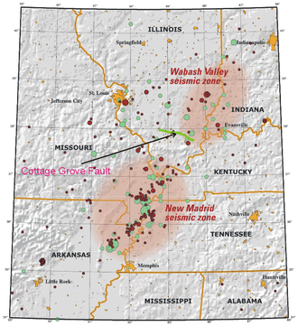
[24] Scientists anticipating a future earthquake suggest the Wabash Valley fault as a possible source, calling it "dangerous".
Steven Obermeir of the United States Geological Survey is one of several scientists who have found sediments suggesting Wabash Valley Fault earthquakes around magnitude 7 on the Richter scale.