1971 San Fernando earthquake
Damage was locally severe in the northern San Fernando Valley and surface faulting was extensive to the south of the epicenter in the mountains, as well as urban settings along city streets and neighborhoods.
The event affected a number of health-care facilities in Sylmar, San Fernando, and other densely populated areas north of central Los Angeles.
The Olive View Medical Center and Veterans Hospital both experienced very heavy damage, and buildings collapsed at both sites, causing the majority of deaths that occurred.
Other sites throughout the Los Angeles area had been instrumented as a result of local ordinances, and an unprecedented amount of strong motion data was recorded, more so than any other event up until that time.
As had happened following other earthquakes in California, legislation related to building codes was once again revised, with laws that specifically addressed the construction of homes or businesses near known active fault zones.
A small number of damaging events have occurred, with three in Santa Barbara (1812, 1925, and 1978) and two in the San Fernando Valley (1971 and 1994), though other faults in the basin that have high Quaternary slip rates have not produced any large earthquakes.
The shaking surpassed building code requirements and exceeded what engineers had prepared for, and although most dwellings in the valley had been built in the prior two decades, even modern earthquake-resistant structures sustained serious damage.
Since both occurred in urban and industrial areas and resulted in significant economic impairment, each event drew critical observation from planning authorities, and has been thoroughly studied in the scientific communities.
Additional breaks occurred farther to the east that were in a more scattered fashion, while the western portion of the most affected area had less pronounced scarps, especially the detached Mission Wells segment.
[14][15] All segments shared the common elements of thrust faulting with a component of left-lateral slip, a general east–west strike, and a northward dip, but they were not unified with regard to their connection to the associated underlying bedrock.
Along the hill fronts of the Tujunga segment, some ambiguous formations were present because some scarps may have had influence from downhill motion, but for the most part they were tectonic in nature.
"[16]The USGS commissioned a private company and the United States Air Force to take aerial photographs over 97 sq mi (250 km2) of the mountainous areas north of the San Fernando Valley.
Part of the reason there were so many stations to capture the event was a 1965 ordinance that required newly constructed buildings in Beverly Hills and Los Angeles over six stories in height to be outfitted with three of the instruments.
As a result of what was considered a fortunate accident, the machine kept recording for six minutes (until it ran out of paper) and provided scientists with additional data on 30 of the initial aftershocks.
The hospital buildings, the freeway overpasses, and the Sylmar Juvenile Hall were on coarse alluvium that overlay thousands of feet of loosely consolidated sedimentary material.
In the city of San Fernando, underground water, sewer, and gas systems suffered breaks too numerous to count, and some sections were so badly damaged that they were abandoned.
Though the reinforced concrete block structure was afflicted by the shock and uplift, the relatively good performance was in stark contrast to that of the Olive View and Veterans Hospital complexes.
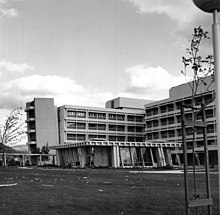
The five-story, reinforced-concrete Medical Treatment and Care Building was one of three new additions to the complex (all three of which sustained damage), was assembled with earthquake-resistant construction techniques, and was completed in December 1970.
Electrical power and communications failed at the hospital at the time of the earthquake, but very few people occupied the lower floors and the stairways at the early hour.
It had been established that these zones had a higher likelihood of experiencing strong ground acceleration, and the plan was made to furnish the selected VA hospitals with two instruments.
The two facilities, located near Grapevine and Weldon canyons that channel water and debris off the Sierra Madre Mountains, are lined by steep ridges and have formed alluvial fans at their mouths.
The Antelope Valley Freeway had damage from Newhall Pass to the northeast, primarily from settling and alignment issues, as well as splintering and cracking at the Santa Clara River and Solemint bridges.
Ground displacement at the site was ruled out as a major cause of the failure, and in addition to the fallen sections and a crane that was struck during the collapse, other portions of the overpass were also damaged.
The westbound I-210 to southbound I-5, which was complete except for paving at the ramp section, collapsed to the north, likely because of vibration that moved the overpass off its supports due to an inadequate seat.
Unlike the situation at the Antelope Valley Interchange, permanent ground movement (defined as several inches of left-lateral displacement with possibly an element of thrusting) was observed in the area.
[26] A large number of public school buildings in the Los Angeles area displayed mixed responses to the shaking, and those that were built after the enforcement of the Field Act clearly showed the results of the reformed construction styles.
Except for the concrete gymnasium, all of the buildings at Sylmar High School (3.75 mi (6.04 km) from Pacoima Dam) were post-Field Act, one-story, wood construction.
The list of items needing improvements included building codes, dams and bridges being made more earthquake resistant, hospitals that are designed to remain operational, and the restriction of development near known fault zones.
[29] California Strong Motion Instrumentation Program Prior to the San Fernando earthquake, some structural engineers had already believed that the existing groundwork for seismic design required enhancement.
Even at that time, engineers were against the idea of constructing buildings to resist the high forces that were seen in the El Centro shock, but after a 1966 earthquake peaked at 0.5 g, and a maximum of 1.25 g was observed at the Pacoima Dam during the San Fernando event, a debate began as to whether that low requirement was sufficient.